
San Juan and Gulf Islands : nautical and recreational planning map
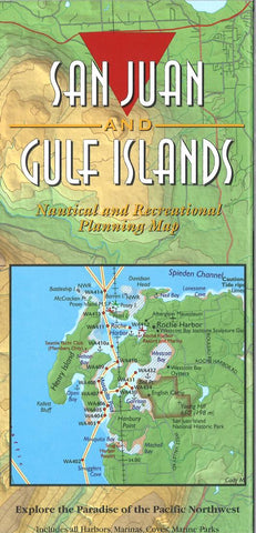
Boating and exploring one of the most popular cruising areas in the world is now easy with this colorful planning map of the San Juan and Gulf Islands. The map covers Deception Pass west to Victoria, and north from Bellingham to Nanaimo. All harbors, coves, anchorages, and Cascade Marine Trail sites for kayaks or canoes are noted, as well as public and Provincial parks. Fine Edges Proven Cruising Routes© are shown with the Latitude/Longitude GPS waypoints listed for all key locations and the turning points for the routes.
The 2 sided map is 36 wide by 24 high and folds to 4 wide by 9 high and is printed on waterproof paper for convenient use on a boat or carrying in a backpack. The back of the map includes the Canadian Gulf Islands and the GPS Waypoints for the routes shown and all major harbors and coves on the map. On the boat, it can be used as a high level overview map of the San Juan and Gulf Islands for trip planning with a dry marker.
- Product Number: FE_SAN_JUAN_18
- Reference Product Number: 2333093M
- ISBN: 9780999356050
- Date of Publication: 6/1/2018
- Folded Size: 9.06 inches high by 3.94 inches wide
- Unfolded (flat) Size: 36.02 inches high by 24.02 inches wide
- Map format: Folded
- Map type: Trade Maps - Outdoor Recreation Maps
- Geographical region: United States
- Geographical subregion: Oregon


