
Field - Emerald Lake - Yoho National Park Adventure Topographic Map
Field - Emerald Lake - Yoho National Park Map BC
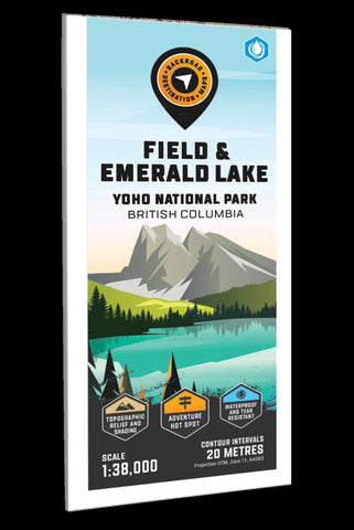
Focusing on the Field, Emerald Lake and Yoho Valley areas of Yoho National Park, this BRMB Adventure topographic map highlights all the access roads, campgrounds, trails for hiking, cross-country skiing, horseback riding and mountain biking, paddling routes, fishing lakes and rivers, backcountry huts and cabins, picnic areas, viewpoints, waterfalls and more! This Adventure map features our industry-leading topographic contours and relief shading and charts the areas of Emerald Lake, Field, Yoho Valley, Cathedral Lakes, Great Divide Trail, Kicking Horse River, Marpole Lake, President Range Mountains, Sherbrooke Lake, Twin Falls, Stanley Mitchell Hut, Takakkaw Falls, Wapta Traverse, Waputik Icefield, Yoho River and more!
The printed version of the map is displayed at 1:40,000 scale on 61 x 94 cm (24 x 37 in) paper on a durable waterproof synthetic material. The Wall Maps have been customized to display nicely and fit into common
- Product Number: BRM_ADV_FIELD_23
- Reference Product Number: - None -
- ISBN: - None -
- Date of Publication: 12/1/2023
- Folded Size: 9 inches high by 4 inches wide
- Unfolded (flat) Size: 37 inches high by 24 inches wide
- Map format: Folded
- Map type: Trade Maps - Outdoor Recreation Maps
- Geographical region: Canada
- Geographical subregion: British Columbia


