
Bonnington Range Adventure Topographic Map
Bonnington Range - BC Adventure Map
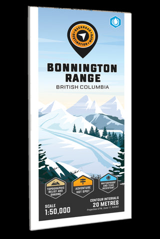
Highlighting the Bonnington Range Backcountry Ski and Snowmobile area near Castlegar, Trail and Nelson British Columbia, this 1:50,000 scale map features the ski route and its access points, backcountry cabins and huts, multi-use, ATV and snowmobile trails, recreation sites, fish species, mountain peaks and creek drainages. Use for backcountry skiing and touring, snowmobiling, ATVing, hiking, camping, exploring, fishing, wildlife viewing and more. With 1:10,000 water and road data, no other map for the area provides you with this level of recreational or topographic detail. Covering the area between Highways 3A, 3B and 6, this map includes Castlegar, Nelson, Salmo, Barrett Creek, Blewett, Bombi Pass, Bonnington Range, Brilliant, Champion Lakes, Crescent Valley, Erie, Erie Creek, Giveout Creek, Glade, Granite, Grassy Hut. Hall, Morning Mountain, Porto Rico, Rover Creek, Siwash Mountain, Slocan Valley, Thrums and more!
The printed version
- Product Number: BRM_ADV_BON_23
- Reference Product Number: - None -
- ISBN: - None -
- Date of Publication: 12/1/2023
- Folded Size: 9 inches high by 4 inches wide
- Unfolded (flat) Size: 37 inches high by 24 inches wide
- Map format: Folded
- Map type: Trade Maps - Outdoor Recreation Maps
- Geographical region: Canada
- Geographical subregion: British Columbia


