
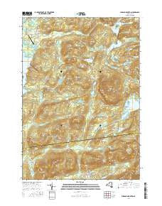
~ Pharaoh Mountain NY topo map, 1:24000 scale, 7.5 X 7.5 Minute, 2016
Pharaoh Mountain, New York, USGS topographic map dated 2016.
Includes geographic coordinates (latitude and longitude). This topographic map is suitable for hiking, camping, and exploring, or framing it as a wall map.
Printed on-demand using high resolution imagery, on heavy weight and acid free paper, or alternatively on a variety of synthetic materials.
Topos available on paper, Waterproof, Poly, or Tyvek. Usually shipping rolled, unless combined with other folded maps in one order.
- Product Number: USGS-8318075
- Free digital map download (high-resolution, GeoPDF): Pharaoh Mountain, New York (file size: 30 MB)
- Map Size: please refer to the dimensions of the GeoPDF map above
- Weight (paper map): ca. 55 grams
- Map Type: POD USGS Topographic Map
- Map Series: US Topo
- Map Verison: Current
- Cell ID: 34933
- Datum: North American Datum of 1983
- Map Projection: Transverse Mercator
- Map Cell Name: Pharaoh Mountain
- Grid size: 7.5 X 7.5 Minute
- Date on map: 2016
- Map Scale: 1:24000
- Geographical region: New York, United States
Neighboring Maps:
All neighboring USGS topo maps are available for sale online at a variety of scales.
Spatial coverage:
Topo map Pharaoh Mountain, New York, covers the geographical area associated the following places:
- Smith and Leland Hill - Spectacle Pond Trail - Coffee Pond - Bear Mountain - Oxshoe Pond - Sugar Hill - Number Six Hill - Beaver Meadow Hill - Rock Pond Brook - Number Eight Hill - Wilson Brook - Horseshoe Pond - Pharaoh Mountain - Goose Pond - Goose Pond Hill - Steep Bay - Pyramid Brook - Desolate Brook - Pharoah Lake - Steep Bay Hill - Franks Hill - Blue Hill - Wilcox Pond - Orange Hill - Pharoah Lake Brook - Pine Hill - Pine Hill - Carey Hill - Gull Pond - Burnt Hill - Park Mountain - Platt Brook - Alder Pond - Whortleberry Pond - Crane Pond - Spectacle Pond - Crab Pond - Alder Creek - Pharoah Mountain Trail - Beaver Meadow Marsh - The Dam Hill - Sucker Hole Hill - Glidden Marsh - Owls Head - Meadow Hill - Long Swing Trail - Burge Pond - Desolate Swamp - Ragged Mountain - Desolate Hill - Stevens Mountain - Antwine Hill - Number Seven Hill - Meadow Cove - Harrison Marsh - Plank Bridge Hill - Number Eight Mountain - Schroon Lake Airport - Shanty Bottom Brook - Third Brother - Lockwood Bay - Crab Pond - Wilson Hill - Chub Pond - Little Stevens - Pyramid Lake - Spectacle Pond Hill
- Map Area ID: AREA43.87543.75-73.75-73.625
- Northwest corner Lat/Long code: USGSNW43.875-73.75
- Northeast corner Lat/Long code: USGSNE43.875-73.625
- Southwest corner Lat/Long code: USGSSW43.75-73.75
- Southeast corner Lat/Long code: USGSSE43.75-73.625
- Northern map edge Latitude: 43.875
- Southern map edge Latitude: 43.75
- Western map edge Longitude: -73.75
- Eastern map edge Longitude: -73.625


