
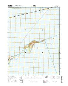
~ Plum Island NY topo map, 1:24000 scale, 7.5 X 7.5 Minute, 2016
Plum Island, New York, USGS topographic map dated 2016.
Includes geographic coordinates (latitude and longitude). This topographic map is suitable for hiking, camping, and exploring, or framing it as a wall map.
Printed on-demand using high resolution imagery, on heavy weight and acid free paper, or alternatively on a variety of synthetic materials.
Topos available on paper, Waterproof, Poly, or Tyvek. Usually shipping rolled, unless combined with other folded maps in one order.
- Product Number: USGS-8290504
- Free digital map download (high-resolution, GeoPDF): Plum Island, New York (file size: 16 MB)
- Map Size: please refer to the dimensions of the GeoPDF map above
- Weight (paper map): ca. 55 grams
- Map Type: POD USGS Topographic Map
- Map Series: US Topo
- Map Verison: Current
- Cell ID: 35709
- Datum: North American Datum of 1983
- Map Projection: Transverse Mercator
- Map Cell Name: Plum Island
- Grid size: 7.5 X 7.5 Minute
- Date on map: 2016
- Map Scale: 1:24000
- Geographical region: New York, United States
Neighboring Maps:
All neighboring USGS topo maps are available for sale online at a variety of scales.
Spatial coverage:
Topo map Plum Island, New York, covers the geographical area associated the following places:
- Plum Island Rock - Orient Point - Oyster Pond Reef - Battery Robert Floyd (historical) - East Point - Battery Bogardus Eldridge (historical) - Gardiners Point - Battery Kelly (historical) - Orient Point Lighthouse - Battery John Greble (historical) - Plum Island Lighthouse - United States Department of Agriculture - Old Silas Rock - Battery Steele (historical) - Plum Island - Battery James Dalliba (historical) - Middle Shoal Rock - The Sluiceway - Fort Tyler (historical) - Battery Stoneman (historical) - Midway Shoal - Middle Ground - Pine Point - Battery Bradford (historical) - Fort Terry (historical) - Gardiners Point Island Lighthouse (historical) - Battery Peter Hagner (historical) - Plum Gut - Battery Edmund Smith (historical) - Latham Cemetery - Bedford Reef - Plum Gut Harbor - Battery Henry Campbell (historical) - Battery Justin Dimick (historical)
- Map Area ID: AREA41.2541.125-72.25-72.125
- Northwest corner Lat/Long code: USGSNW41.25-72.25
- Northeast corner Lat/Long code: USGSNE41.25-72.125
- Southwest corner Lat/Long code: USGSSW41.125-72.25
- Southeast corner Lat/Long code: USGSSE41.125-72.125
- Northern map edge Latitude: 41.25
- Southern map edge Latitude: 41.125
- Western map edge Longitude: -72.25
- Eastern map edge Longitude: -72.125


