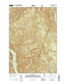
~ Stairs Mountain NH topo map, 1:24000 scale, 7.5 X 7.5 Minute, 2015
Stairs Mountain, New Hampshire, USGS topographic map dated 2015.
Includes geographic coordinates (latitude and longitude). This topographic map is suitable for hiking, camping, and exploring, or framing it as a wall map.
Printed on-demand using high resolution imagery, on heavy weight and acid free paper, or alternatively on a variety of synthetic materials.
Topos available on paper, Waterproof, Poly, or Tyvek. Usually shipping rolled, unless combined with other folded maps in one order.
- Product Number: USGS-7869650
- Free digital map download (high-resolution, GeoPDF): Stairs Mountain, New Hampshire (file size: 27 MB)
- Map Size: please refer to the dimensions of the GeoPDF map above
- Weight (paper map): ca. 55 grams
- Map Type: POD USGS Topographic Map
- Map Series: US Topo
- Map Verison: Current
- Cell ID: 42829
- Datum: North American Datum of 1983
- Map Projection: Transverse Mercator
- Map Cell Name: Stairs Mountain
- Grid size: 7.5 X 7.5 Minute
- Date on map: 2015
- Map Scale: 1:24000
- Geographical region: New Hampshire, United States
Neighboring Maps:
All neighboring USGS topo maps are available for sale online at a variety of scales.
Spatial coverage:
Topo map Stairs Mountain, New Hampshire, covers the geographical area associated the following places:
- Mount Eisenhower - Glen Boulder Trail - Shelter Number Two - Dry River Camping Area - Presidential Range - Mount Resolution - Rocky Branch Trail - Sargents Purchase - Stairs Col Trail - Glen Boulder - Montalban Ridge - Mount Clinton Trail - Shelter Number One - Branch Ridge - Mizpah Spring Hut - Hadleys Purchase - Dry River - Dry River Trail - Rocky Branch Number One WMNF Shelter - Shelter Number One - Upper Stairs Brook - Dry River Campground - Isolation Shelter - Stairs Mountain - Town of Hart's Location - Mount Isolation - Crawford Notch - Rocky Branch Ridge - Mount Parker Trail - Isolation Trail - Maple Mountain - Mount Davis - Davis Path - Gulf of Slides - Willey House Post Office - Mount Pierce - Presidential Range-Dry River Wilderness - Gulf Peak - Giant Stairs - Mount Franklin - Crawford Path - Shelter Number Two - Mount Jackson - Resolution Shelter - Oakes Gulf - Mount Crawford - Davis Brook - Glen Ellis Falls - Glen Ellis Falls Picnic Area - Engine Hill - Frankenstein Cliff - Stairs Brook Trail - Edmands Path - Cutts Grant - Mount Pleasant Trail - Bemis Brook - Lost Pond - Glen Ellis Falls Scenic Area - Lower Stairs Brook - Otis Brook - Oakes Gulf Trail - Sleeper Brook - Miles Brook Trail - Mount Eisenhower Trail - Desolation Pond
- Map Area ID: AREA44.2544.125-71.375-71.25
- Northwest corner Lat/Long code: USGSNW44.25-71.375
- Northeast corner Lat/Long code: USGSNE44.25-71.25
- Southwest corner Lat/Long code: USGSSW44.125-71.375
- Southeast corner Lat/Long code: USGSSE44.125-71.25
- Northern map edge Latitude: 44.25
- Southern map edge Latitude: 44.125
- Western map edge Longitude: -71.375
- Eastern map edge Longitude: -71.25