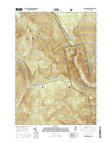
~ Crawford Notch NH topo map, 1:24000 scale, 7.5 X 7.5 Minute, 2015
Crawford Notch, New Hampshire, USGS topographic map dated 2015.
Includes geographic coordinates (latitude and longitude). This topographic map is suitable for hiking, camping, and exploring, or framing it as a wall map.
Printed on-demand using high resolution imagery, on heavy weight and acid free paper, or alternatively on a variety of synthetic materials.
Topos available on paper, Waterproof, Poly, or Tyvek. Usually shipping rolled, unless combined with other folded maps in one order.
- Product Number: USGS-7868978
- Free digital map download (high-resolution, GeoPDF): Crawford Notch, New Hampshire (file size: 28 MB)
- Map Size: please refer to the dimensions of the GeoPDF map above
- Weight (paper map): ca. 55 grams
- Map Type: POD USGS Topographic Map
- Map Series: US Topo
- Map Verison: Current
- Cell ID: 10627
- Datum: North American Datum of 1983
- Map Projection: Transverse Mercator
- Map Cell Name: Crawford Notch
- Grid size: 7.5 X 7.5 Minute
- Date on map: 2015
- Map Scale: 1:24000
- Geographical region: New Hampshire, United States
Neighboring Maps:
All neighboring USGS topo maps are available for sale online at a variety of scales.
Spatial coverage:
Topo map Crawford Notch, New Hampshire, covers the geographical area associated the following places:
- Whitewall Brook - Silver Cascade - Arethusa Falls - Ethan Pond - Tisdale Spring - Zeacliff Trail - Stillwater By-Pass - Crawford House - Mount Field Brook - Ethan Pond Trail - Havie Brook - Mount Stickney - Elephant Head - Zealand Notch - Jumping Brook - Shoal Pond Trail - Zealand Trail - Elephant Head Brook - Mount Willey - Ammonoosuc Lake - White Mountain National Forest - Willey House Camps - Avalon Trail - Thoreau Falls Trail - Mount Webster Trail - Mount Willard - Webster Trail - Shoal Pond - Mount Webster - Webster Cliff Trail - Whitewall Mount - Willey Brook - Lincoln Woods Scenic Area - Willey House - Mount Tom Brook - Wiley Range Trail - Hale Brook - Gibbs Brook - Mount Avalon Trail - A-Z Trail - Ripley Falls - Zealand Falls - Webster Brook - Kedron Brook - Mount Rosebrook - Saco Lake - Thoreau Falls - Mount Avalon - Zealand Valley Trail - Mount Rosebrook Trail - Ethan Pond Shelter - Gibbs Brook Scenic Area - Beans Grant - Flume Cascade - Crawford Notch State Reservation - Zealand Pond - Mount Bemis - Mount Field - Rosebrook Mountains - Avalanche Brook - Mount Echo - Mount Tom
- Map Area ID: AREA44.2544.125-71.5-71.375
- Northwest corner Lat/Long code: USGSNW44.25-71.5
- Northeast corner Lat/Long code: USGSNE44.25-71.375
- Southwest corner Lat/Long code: USGSSW44.125-71.5
- Southeast corner Lat/Long code: USGSSE44.125-71.375
- Northern map edge Latitude: 44.25
- Southern map edge Latitude: 44.125
- Western map edge Longitude: -71.5
- Eastern map edge Longitude: -71.375