
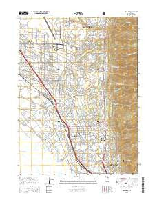
~ Kaysville UT topo map, 1:24000 scale, 7.5 X 7.5 Minute, Current, 2014
Kaysville, Utah, USGS topographic map dated 2014.
Includes geographic coordinates (latitude and longitude). This topographic map is suitable for hiking, camping, and exploring, or framing it as a wall map.
Printed on-demand using high resolution imagery, on heavy weight and acid free paper, or alternatively on a variety of synthetic materials.
Topos available on paper, Waterproof, Poly, or Tyvek. Usually shipping rolled, unless combined with other folded maps in one order.
- Product Number: USGS-7787129
- Free digital map download (high-resolution, GeoPDF): Kaysville, Utah (file size: 33 MB)
- Map Size: please refer to the dimensions of the GeoPDF map above
- Weight (paper map): ca. 55 grams
- Map Type: POD USGS Topographic Map
- Map Series: US Topo
- Map Verison: Current
- Cell ID: 23103
- Datum: North American Datum of 1983
- Map Projection: Transverse Mercator
- Map Cell Name: Kaysville
- Grid size: 7.5 X 7.5 Minute
- Date on map: 2014
- Map Scale: 1:24000
- Geographical region: Utah, United States
Neighboring Maps:
All neighboring USGS topo maps are available for sale online at a variety of scales.
Spatial coverage:
Topo map Kaysville, Utah, covers the geographical area associated the following places:
- Wheat Ridge - Holt - Canyon Cove Estates - Hods Hollow - Walker - North Hills Estates - Clarinda - Palos Verde Estates - David Smith - Colonies of East Pointe - Wasatch Heights - Farifield Park - Sommerset Hollow - Carrie Heights - Cherry Lane Heights - Happy Home Five - Quail Point - Tri Oaks - Nayon Heights Condominium - Hob Hill - Oakridge Highlands - Kaysville - Country Creek Estates - Grand Oaks - Hidden Hideaway Condominium - Summer Haze - East Layton - Rachels Place - Aspen Heights - Creek View Estates - The Orchard - Simmons - Green Briar West - West Layton - Parkdale - The Meadows - Somerset Place Condominium - Whitesides Estates - Phyllis - Sundowner Condominium - Meadowbrook Hollow - Church Street - Colonial Park - Oak Forest One - North Farmington Junction - Pilly Green - Cameron Estates - Clair Black - Valley Hi - Fort Lane Plaza Condominium - Brookhurst - Royal Farms Estates - Misty Meadows - Peachwood Estates - Marketboro Condostor Condominium - Barker - Oak Hill - Alta Acres - Oakridge Village - Eastview - Moon Park - LaDonna Mesa - Country Oaks Condominium - Shepherd Creek County Estates - Peach Tree - Cherry View - Lupine Village - Clover Estates - Eastridge Estates - Church Hill Estates - East Oaks - Upland - Mutton Hollow Acres - Gailey - King - Rolling Oaks - Glendale Gardens - Johns Acres - Oakridge Village Condominium - Summerfield - Nalder Heights - East Crest Estates - Layton Park Plaza Condominium - Golden Acres - Natural Estates - Vantage Park - Heather Hills - Mountain Terrace Estates - Country Meadows - Oakmont Acres - Harvey Farm Estates - Homeplace - Chapel Hill - Robinwood - Dawn Development - Tanglewood - Marshall Heights - King Farm Estates - Barton Manor Two - Gill
- Map Area ID: AREA41.12541-112-111.875
- Northwest corner Lat/Long code: USGSNW41.125-112
- Northeast corner Lat/Long code: USGSNE41.125-111.875
- Southwest corner Lat/Long code: USGSSW41-112
- Southeast corner Lat/Long code: USGSSE41-111.875
- Northern map edge Latitude: 41.125
- Southern map edge Latitude: 41
- Western map edge Longitude: -112
- Eastern map edge Longitude: -111.875


