
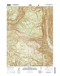
~ Iron Mine Mountain UT topo map, 1:24000 scale, 7.5 X 7.5 Minute, Current, 2014
Iron Mine Mountain, Utah, USGS topographic map dated 2014.
Includes geographic coordinates (latitude and longitude). This topographic map is suitable for hiking, camping, and exploring, or framing it as a wall map.
Printed on-demand using high resolution imagery, on heavy weight and acid free paper, or alternatively on a variety of synthetic materials.
Topos available on paper, Waterproof, Poly, or Tyvek. Usually shipping rolled, unless combined with other folded maps in one order.
- Product Number: USGS-7786969
- Free digital map download (high-resolution, GeoPDF): Iron Mine Mountain, Utah (file size: 34 MB)
- Map Size: please refer to the dimensions of the GeoPDF map above
- Weight (paper map): ca. 55 grams
- Map Type: POD USGS Topographic Map
- Map Series: US Topo
- Map Verison: Current
- Cell ID: 22058
- Datum: North American Datum of 1983
- Map Projection: Transverse Mercator
- Map Cell Name: Iron Mine Mountain
- Grid size: 7.5 X 7.5 Minute
- Date on map: 2014
- Map Scale: 1:24000
- Geographical region: Utah, United States
Neighboring Maps:
All neighboring USGS topo maps are available for sale online at a variety of scales.
Spatial coverage:
Topo map Iron Mine Mountain, Utah, covers the geographical area associated the following places:
- Mill Flat - Iron Mine Campground - Duchesne Monument - Little Pond - Iron Mine Lake - Cold Spring - Trail Hollow - Spruce Springs Reservoir - Little Deer Creek - Cobble Creek - Iron Mine Mountain - Smooth Rock Falls - Iron Mine Creek - Lambert Meadow - Broadhead Lake - West Portal - Cobblerest Campground - Cataract Gorge - Alexander Lake - Defas Dude Ranch - Duchesne Tunnel - East Portal - Mill Flat Campground - Hades Rhoades Tunnel - East Portal Duchesne Tunnel - Beaver Creek - Hades Recreation Site - Shale Creek
- Map Area ID: AREA40.62540.5-111-110.875
- Northwest corner Lat/Long code: USGSNW40.625-111
- Northeast corner Lat/Long code: USGSNE40.625-110.875
- Southwest corner Lat/Long code: USGSSW40.5-111
- Southeast corner Lat/Long code: USGSSE40.5-110.875
- Northern map edge Latitude: 40.625
- Southern map edge Latitude: 40.5
- Western map edge Longitude: -111
- Eastern map edge Longitude: -110.875


