
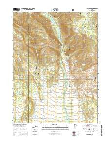
~ Ice Cave Peak UT topo map, 1:24000 scale, 7.5 X 7.5 Minute, Current, 2014
Ice Cave Peak, Utah, USGS topographic map dated 2014.
Includes geographic coordinates (latitude and longitude). This topographic map is suitable for hiking, camping, and exploring, or framing it as a wall map.
Printed on-demand using high resolution imagery, on heavy weight and acid free paper, or alternatively on a variety of synthetic materials.
Topos available on paper, Waterproof, Poly, or Tyvek. Usually shipping rolled, unless combined with other folded maps in one order.
- Product Number: USGS-7786955
- Free digital map download (high-resolution, GeoPDF): Ice Cave Peak, Utah (file size: 33 MB)
- Map Size: please refer to the dimensions of the GeoPDF map above
- Weight (paper map): ca. 55 grams
- Map Type: POD USGS Topographic Map
- Map Series: US Topo
- Map Verison: Current
- Cell ID: 21667
- Datum: North American Datum of 1983
- Map Projection: Transverse Mercator
- Map Cell Name: Ice Cave Peak
- Grid size: 7.5 X 7.5 Minute
- Date on map: 2014
- Map Scale: 1:24000
- Geographical region: Utah, United States
Neighboring Maps:
All neighboring USGS topo maps are available for sale online at a variety of scales.
Spatial coverage:
Topo map Ice Cave Peak, Utah, covers the geographical area associated the following places:
- Woodard Spring - Big Tom Hollow - Cart Hollow - Lees Hollow - Wild Horse Draw - Horricks Spring - East Cart Hollow Reservoir - Bridger Canyon - The Hole - Elkhorn Guard Station - Upper Big Tom Hollow Spring - Bathtub Trough - Cottonwood Spring - Birch Spring - Elkhorn Trough - Hominy Creek - Cart Hollow Spring - Sulphur Spring - Farm Creek Grazing Enclosure - Murray Spring - Farm Creek Bridge - Ice Cave Peak - Whiterocks Canal - Red Pine Spring - Henry Olsen Draw - Upper Cart Hollow Springs - Bull Pasture - Sand Point Spring - Red Knoll - Reeds Cemetery - Red Pine Canyon - Buck Ridge - Snake John Spring - Whiterocks Campground - Farm Creek Canal - Paradise Creek - Whiterocks - Cuch Spring - Ralphs Canyon - Coal Mine Draw - Loggers Cabin Park - Ice Cave Spring - Mosby Mountain - Bench Spring - Rat Spring - Lower Big Tom Hollow Spring
- Map Area ID: AREA40.62540.5-110-109.875
- Northwest corner Lat/Long code: USGSNW40.625-110
- Northeast corner Lat/Long code: USGSNE40.625-109.875
- Southwest corner Lat/Long code: USGSSW40.5-110
- Southeast corner Lat/Long code: USGSSE40.5-109.875
- Northern map edge Latitude: 40.625
- Southern map edge Latitude: 40.5
- Western map edge Longitude: -110
- Eastern map edge Longitude: -109.875


