
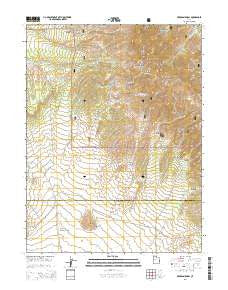
~ Erickson Knoll UT topo map, 1:24000 scale, 7.5 X 7.5 Minute, Current, 2014
Erickson Knoll, Utah, USGS topographic map dated 2014.
Includes geographic coordinates (latitude and longitude). This topographic map is suitable for hiking, camping, and exploring, or framing it as a wall map.
Printed on-demand using high resolution imagery, on heavy weight and acid free paper, or alternatively on a variety of synthetic materials.
Topos available on paper, Waterproof, Poly, or Tyvek. Usually shipping rolled, unless combined with other folded maps in one order.
- Product Number: USGS-7786103
- Free digital map download (high-resolution, GeoPDF): Erickson Knoll, Utah (file size: 35 MB)
- Map Size: please refer to the dimensions of the GeoPDF map above
- Weight (paper map): ca. 55 grams
- Map Type: POD USGS Topographic Map
- Map Series: US Topo
- Map Verison: Current
- Cell ID: 14488
- Datum: North American Datum of 1983
- Map Projection: Transverse Mercator
- Map Cell Name: Erickson Knoll
- Grid size: 7.5 X 7.5 Minute
- Date on map: 2014
- Map Scale: 1:24000
- Geographical region: Utah, United States
Neighboring Maps:
All neighboring USGS topo maps are available for sale online at a variety of scales.
Spatial coverage:
Topo map Erickson Knoll, Utah, covers the geographical area associated the following places:
- Meadow Creek - South Pine Canyon - Erickson Knoll - Wright Ranch - Desert Springs - Hilltop Mine - Burned Canyon - Lion Hill Spring - Elderberry Creek - Copper Jack Mine - Black Crook Peak - Upper Pine Grove - Flying Dutchman Mine - Black Crook Creek - Sheeprock Canyon - Black Ranch - Ekker Ranch - Right Fork South Oak Brush Canyon - South Oak Brush Wash - Mud Spring - Hard to Beat Canyon - Clinger Mine - Cottonwood Canyon - Black Spring - Left Fork South Oak Brush Canyon - Lower Pine Grove - Erickson Pass - Lion Hill - Utah Mine
- Map Area ID: AREA4039.875-112.625-112.5
- Northwest corner Lat/Long code: USGSNW40-112.625
- Northeast corner Lat/Long code: USGSNE40-112.5
- Southwest corner Lat/Long code: USGSSW39.875-112.625
- Southeast corner Lat/Long code: USGSSE39.875-112.5
- Northern map edge Latitude: 40
- Southern map edge Latitude: 39.875
- Western map edge Longitude: -112.625
- Eastern map edge Longitude: -112.5


