
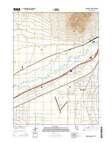
~ Winnemucca West NV topo map, 1:24000 scale, 7.5 X 7.5 Minute, 2014
Winnemucca West, Nevada, USGS topographic map dated 2014.
Includes geographic coordinates (latitude and longitude). This topographic map is suitable for hiking, camping, and exploring, or framing it as a wall map.
Printed on-demand using high resolution imagery, on heavy weight and acid free paper, or alternatively on a variety of synthetic materials.
Topos available on paper, Waterproof, Poly, or Tyvek. Usually shipping rolled, unless combined with other folded maps in one order.
- Product Number: USGS-7235162
- Free digital map download (high-resolution, GeoPDF): Winnemucca West, Nevada (file size: 22 MB)
- Map Size: please refer to the dimensions of the GeoPDF map above
- Weight (paper map): ca. 55 grams
- Map Type: POD USGS Topographic Map
- Map Series: US Topo
- Map Verison: Current
- Cell ID: 49498
- Datum: North American Datum of 1983
- Map Projection: Transverse Mercator
- Map Cell Name: Winnemucca West
- Grid size: 7.5 X 7.5 Minute
- Date on map: 2014
- Map Scale: 1:24000
- Geographical region: Nevada, United States
Neighboring Maps:
All neighboring USGS topo maps are available for sale online at a variety of scales.
Spatial coverage:
Topo map Winnemucca West, Nevada, covers the geographical area associated the following places:
- Westmoreland Ranch - Winnemucca Mine - Union Series Mine - Pride of the Mountain Mine - Thomas Creek - Winnemucca Municipal Airport - Arigo Series Mine - S Thomas Ranch - Winnemucca Rural Fire Department Station 2 - Benin (historical) - Santa Rosa Creek - Williams Station - Krum (historical) - Union Township - Granite Ravine - Winnemucca Mining District
- Map Area ID: AREA4140.875-117.875-117.75
- Northwest corner Lat/Long code: USGSNW41-117.875
- Northeast corner Lat/Long code: USGSNE41-117.75
- Southwest corner Lat/Long code: USGSSW40.875-117.875
- Southeast corner Lat/Long code: USGSSE40.875-117.75
- Northern map edge Latitude: 41
- Southern map edge Latitude: 40.875
- Western map edge Longitude: -117.875
- Eastern map edge Longitude: -117.75


