
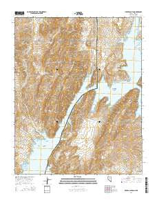
~ Iceberg Canyon NV topo map, 1:24000 scale, 7.5 X 7.5 Minute, 2014
Iceberg Canyon, Nevada, USGS topographic map dated 2014.
Includes geographic coordinates (latitude and longitude). This topographic map is suitable for hiking, camping, and exploring, or framing it as a wall map.
Printed on-demand using high resolution imagery, on heavy weight and acid free paper, or alternatively on a variety of synthetic materials.
Topos available on paper, Waterproof, Poly, or Tyvek. Usually shipping rolled, unless combined with other folded maps in one order.
- Product Number: USGS-7172704
- Free digital map download (high-resolution, GeoPDF): Iceberg Canyon, Nevada (file size: 27 MB)
- Map Size: please refer to the dimensions of the GeoPDF map above
- Weight (paper map): ca. 55 grams
- Map Type: POD USGS Topographic Map
- Map Series: US Topo
- Map Verison: Current
- Cell ID: 21671
- Datum: North American Datum of 1983
- Map Projection: Transverse Mercator
- Map Cell Name: Iceberg Canyon
- Grid size: 7.5 X 7.5 Minute
- Date on map: 2014
- Map Scale: 1:24000
- Geographical region: Nevada, United States
Neighboring Maps:
All neighboring USGS topo maps are available for sale online at a variety of scales.
Spatial coverage:
Topo map Iceberg Canyon, Nevada, covers the geographical area associated the following places:
- Pigeon Wash - Wheeler Ridge - Driftwood Cove - Indian Hills Wash - Iceberg Reef - Sunfish Cove - North Howland Cove - Connoly Wash - Crappie Cove - New Spring - Bradley Bay - Thumb Knob - Twin Coves - Connoly Spring - Indian Hills - Iceberg Ridge - Million Hills - New Spring Wash - Million Hills Wash - Devils Cove - Line Cove - Cottonwood Canyon - Badger Cove - Cormorant Cliffs - Grand Wash Canyon - Driftwood Island - Boundary Hill - Iceberg Canyon - Burro Spring Wash - South American Point - Grand Wash Bay - Lava Point - Paiute Point - Center Point - Cottonwood Wash - Iceberg Canyon - South Howland Cove - Cormorant Cove - Iceberg Rapid - Chuckwalla Cove - Howland Point - Boundary Point
- Map Area ID: AREA36.2536.125-114.125-114
- Northwest corner Lat/Long code: USGSNW36.25-114.125
- Northeast corner Lat/Long code: USGSNE36.25-114
- Southwest corner Lat/Long code: USGSSW36.125-114.125
- Southeast corner Lat/Long code: USGSSE36.125-114
- Northern map edge Latitude: 36.25
- Southern map edge Latitude: 36.125
- Western map edge Longitude: -114.125
- Eastern map edge Longitude: -114


