
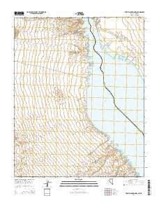
~ Spirit Mountain NW NV topo map, 1:24000 scale, 7.5 X 7.5 Minute, 2014
Spirit Mountain NW, Nevada, USGS topographic map dated 2014.
Includes geographic coordinates (latitude and longitude). This topographic map is suitable for hiking, camping, and exploring, or framing it as a wall map.
Printed on-demand using high resolution imagery, on heavy weight and acid free paper, or alternatively on a variety of synthetic materials.
Topos available on paper, Waterproof, Poly, or Tyvek. Usually shipping rolled, unless combined with other folded maps in one order.
- Product Number: USGS-7169439
- Free digital map download (high-resolution, GeoPDF): Spirit Mountain NW, Nevada (file size: 22 MB)
- Map Size: please refer to the dimensions of the GeoPDF map above
- Weight (paper map): ca. 55 grams
- Map Type: POD USGS Topographic Map
- Map Series: US Topo
- Map Verison: Current
- Cell ID: 42516
- Datum: North American Datum of 1983
- Map Projection: Transverse Mercator
- Map Cell Name: Spirit Mountain NW
- Grid size: 7.5 X 7.5 Minute
- Date on map: 2014
- Map Scale: 1:24000
- Geographical region: Nevada, United States
Neighboring Maps:
All neighboring USGS topo maps are available for sale online at a variety of scales.
Spatial coverage:
Topo map Spirit Mountain NW, Nevada, covers the geographical area associated the following places:
- Cottonwood Valley Cove - Airport Cove - Quartette (historical) - Dead Cove - Nine Mile Coves - Hog Farm Cove - Windmill Cove - Cottonwood Island Cove - Cottonwood Cove - Cottonwood East Area - Six Mile Cove - North Basin Light Cove - Tequila Cove - Six Mile Area - Nellis Wash Wilderness - Cottontail Cove - Ski Cove - Lake Mohave - Lost Cove - Mesquite Cove - Three Sisters Cove - Bill Gayes Cove - Nellis Cove - Cottonwood Landing Field (historical) - Riverside Ranch (historical) - Mesa Cove - Cottonwood Cove Rural Branch Post Office - Cottonwood Valley - D Hutton Ranch (historical) - Pot Cove - Five Rapids (historical) - Levi Cove - Water Wheel Cove - Cottonwood Island (historical) - Sandy Point Cove - Cottonwood Camp (historical) - Carp Cove - Nellis Wash - Searchlight Ferry - Cottonwood Cove - Finger Cove - Box Cove - Gremlin Cove
- Map Area ID: AREA35.535.375-114.75-114.625
- Northwest corner Lat/Long code: USGSNW35.5-114.75
- Northeast corner Lat/Long code: USGSNE35.5-114.625
- Southwest corner Lat/Long code: USGSSW35.375-114.75
- Southeast corner Lat/Long code: USGSSE35.375-114.625
- Northern map edge Latitude: 35.5
- Southern map edge Latitude: 35.375
- Western map edge Longitude: -114.75
- Eastern map edge Longitude: -114.625


