
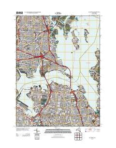
~ Flushing NY topo map, 1:24000 scale, 7.5 X 7.5 Minute, Historical, 2013
Flushing, New York, USGS topographic map dated 2013.
Includes geographic coordinates (latitude and longitude). This topographic map is suitable for hiking, camping, and exploring, or framing it as a wall map.
Printed on-demand using high resolution imagery, on heavy weight and acid free paper, or alternatively on a variety of synthetic materials.
Topos available on paper, Waterproof, Poly, or Tyvek. Usually shipping rolled, unless combined with other folded maps in one order.
- Product Number: USGS-5940605
- Free digital map download (high-resolution, GeoPDF): Flushing, New York (file size: 21 MB)
- Map Size: please refer to the dimensions of the GeoPDF map above
- Weight (paper map): ca. 55 grams
- Map Type: POD USGS Topographic Map
- Map Series: US Topo
- Map Verison: Historical
- Cell ID: 15664
- Datum: North American Datum of 1983
- Map Projection: Transverse Mercator
- Map Cell Name: Flushing
- Grid size: 7.5 X 7.5 Minute
- Date on map: 2013
- Map Scale: 1:24000
- Geographical region: New York, United States
Neighboring Maps:
All neighboring USGS topo maps are available for sale online at a variety of scales.
Spatial coverage:
Topo map Flushing, New York, covers the geographical area associated the following places:
- Country Club - Van Nest - Parkchester - Eastchester Houses - Unionport - Jamie Towers - Bronx - Rosedale Houses - Throgs Neck - Eastchester Bay - Co-Op City - Silver Beach - Parsons Beach - Sound View Houses - Sack Wern Houses - Schuylerville - James Monroe Houses - Park of Edgewater - Throgs Neck Houses - Murray Hill - Pelham Bay - Bronxdale Houses - Parkside Houses - Beechhurst - Pelham Parkway Houses - Clason Point - Clason Point Gardens Houses - Lafayette Morrison Houses - Locust Point - Spencer Estates - Middletown - East Elmhurst - Whitestone - Flushing - Morris Park - Westchester - Bird Grove - Bayside - College Point - Bronxdale - Linden Hill - City Island - Oakland Gardens - Malba - Baychester - Castle Hill Houses
- Map Area ID: AREA40.87540.75-73.875-73.75
- Northwest corner Lat/Long code: USGSNW40.875-73.875
- Northeast corner Lat/Long code: USGSNE40.875-73.75
- Southwest corner Lat/Long code: USGSSW40.75-73.875
- Southeast corner Lat/Long code: USGSSE40.75-73.75
- Northern map edge Latitude: 40.875
- Southern map edge Latitude: 40.75
- Western map edge Longitude: -73.875
- Eastern map edge Longitude: -73.75


