
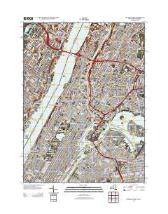
~ Central Park NY topo map, 1:24000 scale, 7.5 X 7.5 Minute, Historical, 2013
Central Park, New York, USGS topographic map dated 2013.
Includes geographic coordinates (latitude and longitude). This topographic map is suitable for hiking, camping, and exploring, or framing it as a wall map.
Printed on-demand using high resolution imagery, on heavy weight and acid free paper, or alternatively on a variety of synthetic materials.
Topos available on paper, Waterproof, Poly, or Tyvek. Usually shipping rolled, unless combined with other folded maps in one order.
- Product Number: USGS-5940599
- Free digital map download (high-resolution, GeoPDF): Central Park, New York (file size: 25 MB)
- Map Size: please refer to the dimensions of the GeoPDF map above
- Weight (paper map): ca. 55 grams
- Map Type: POD USGS Topographic Map
- Map Series: US Topo
- Map Verison: Historical
- Cell ID: 7974
- Datum: North American Datum of 1983
- Map Projection: Transverse Mercator
- Map Cell Name: Central Park
- Grid size: 7.5 X 7.5 Minute
- Date on map: 2013
- Map Scale: 1:24000
- Geographical region: New York, United States
Neighboring Maps:
All neighboring USGS topo maps are available for sale online at a variety of scales.
Spatial coverage:
Topo map Central Park, New York, covers the geographical area associated the following places:
- Carnegie Hill - Lambert Houses - Colonial Park Houses - Port Morris - Manhattanville - Forest Houses - Washington Heights - Leonia - Ravenswood Houses - Konaande Kongh (historical) - James Weldon Johnson Houses - Sedgwick Houses - Hamilton Houses - Upper West Side - Highbridge Houses - Jackson Heights - Fairview - Riverbend Houses - Harbor View Terrace - Stanley Isaacs Houses - Amsterdam Houses - Queensbridge Houses - Coytesville - Clinton - Melrose - Hell's Kitchen - Fordham - John Adams Houses - East Tremont - Morrisania - Tremont - High Bridge - San Juan Hill - Manhattan - Linwood - Yorkville - Mott Haven - Plaza De Los Angeles - Esplanade Gardens - Delano Village - Harlem River Houses - Hunts Point - Charlotteville (historical) - Morris Heights - Bedford Park - Phipps Houses - Fort Lee - Harlem - Le Petit Senegal - Seneca Village (historical) - West Farms - Hamilton Heights - Borgia Butler Houses - Lionel Hampton Houses - Garden Bay Manor - Carmansville (historical) - Park West Village - Palisades Park - Harsenville (historical) - Taino Towers - Bronx River Houses - Gouverneur Morris Houses - Belmont - Astoria - Plaza Borinquen - Patterson Houses - University Heights - Kings Bridge Heights - Jackson Houses - Grantwood - Polo Grounds Houses - Steinway - Woodside Houses - Melrose Houses - Sugar Hill - Gracie Square - Edgewater - North Beach - Soundview Park Homes - Cliffside Park - Charlotte Gardens - East Harlem - Concourse Village - Daniel Webster Houses - Mill Brook Houses - Dyckman Houses - Morningside Heights - Franklin Houses - Saint Mary's Park Houses - Inwood - William McKinley Houses - Fordham Hill - Lewis S Davidson Senior Houses
- Map Area ID: AREA40.87540.75-74-73.875
- Northwest corner Lat/Long code: USGSNW40.875-74
- Northeast corner Lat/Long code: USGSNE40.875-73.875
- Southwest corner Lat/Long code: USGSSW40.75-74
- Southeast corner Lat/Long code: USGSSE40.75-73.875
- Northern map edge Latitude: 40.875
- Southern map edge Latitude: 40.75
- Western map edge Longitude: -74
- Eastern map edge Longitude: -73.875


