
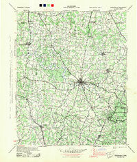
~ Shelbyville TN topo map, 1:100000 scale, 30 X 30 Minute, Historical, 1944
Shelbyville, Tennessee, USGS topographic map dated 1944.
Includes geographic coordinates (latitude and longitude). This topographic map is suitable for hiking, camping, and exploring, or framing it as a wall map.
Printed on-demand using high resolution imagery, on heavy weight and acid free paper, or alternatively on a variety of synthetic materials.
Topos available on paper, Waterproof, Poly, or Tyvek. Usually shipping rolled, unless combined with other folded maps in one order.
- Product Number: USGS-5689674
- Free digital map download (high-resolution, GeoPDF): Shelbyville, Tennessee (file size: 11 MB)
- Map Size: please refer to the dimensions of the GeoPDF map above
- Weight (paper map): ca. 55 grams
- Map Type: POD USGS Topographic Map
- Map Series: HTMC
- Map Verison: Historical
- Cell ID: 396024
- Scan ID: 153425
- Woodland Tint: Yes
- Datum: NAD27
- Map Projection: Polyconic
- Map published by United States Army Corps of Engineers
- Map published by United States Army
- Map published by United States Department of War
- Map Language: English
- Scanner Resolution: 600 dpi
- Map Cell Name: Shelbyville
- Grid size: 30 X 30 Minute
- Date on map: 1944
- Map Scale: 1:100000
- Geographical region: Tennessee, United States
Neighboring Maps:
All neighboring USGS topo maps are available for sale online at a variety of scales.
Spatial coverage:
Topo map Shelbyville, Tennessee, covers the geographical area associated the following places:
- Petersburg - Browns Shop - Cortner - Forest Hills - Willow Grove - Lynchburg - Elbethel - Blakeville - Holts Corner - Bledsoe - Caldwell - Shelbyville - Thick - Anchor Mill - Bakertown - Holly Grove - Taylor Crossroads - Poplins Crossroads - Clay Hill - Beasley - Cumberland Springs - Hawthorne - Colonial Estates - Roseville - Unionville - Elils Ranch Acres - Ledfords Mill - Rover - Midway - Normandy - Midland - Belfast - Holtland - Pleasant Grove - Chapel Hill - Countyline - Short Creek - Raysville - Hickory Hill - Carter Crossroads - Webbs Jungle - Longview - Riggs Crossroads - Richmond - Hilltop - Fall Creek - Bottle Hollow - Vannatta - Union Ridge - Kellertown - Walnut Grove - Bugscuffle - Shelbyville Mills - Mount Olivet (historical) - Concord - Sims Spring - Mount Herman - Delina - Whitaker - Wilhoite Mills - Newtown - Cortners Mill - Fosterville - Greenwood - Flat Creek - Bedford - Fairfield - Halls Mill - Rich Creek - Old Millersburg (historical) - Deason - Oak Hill - Christiana - Wartrace - Plainview - Awalt (historical) - Singleton - Ridgeville - Beechwood - Old Fosterville (historical) - Talley - Gum Road Subdivision - Gum - Haley - Luna - Catalpa - Smyrna - Raus - Bunker Hill - Pleasant Hill - Bell Buckle - Fairlane Estates - Shiloh - R T Estates - Palmetto - Turkey Creek - Steeplechase Meadows - Orrs - Branchville - Bidwell
- Map Area ID: AREA35.7535.25-86.75-86.25
- Northwest corner Lat/Long code: USGSNW35.75-86.75
- Northeast corner Lat/Long code: USGSNE35.75-86.25
- Southwest corner Lat/Long code: USGSSW35.25-86.75
- Southeast corner Lat/Long code: USGSSE35.25-86.25
- Northern map edge Latitude: 35.75
- Southern map edge Latitude: 35.25
- Western map edge Longitude: -86.75
- Eastern map edge Longitude: -86.25


