
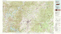
~ Cookeville TN topo map, 1:100000 scale, 30 X 60 Minute, Historical, 1982, updated 1983
Cookeville, Tennessee, USGS topographic map dated 1982.
Includes geographic coordinates (latitude and longitude). This topographic map is suitable for hiking, camping, and exploring, or framing it as a wall map.
Printed on-demand using high resolution imagery, on heavy weight and acid free paper, or alternatively on a variety of synthetic materials.
Topos available on paper, Waterproof, Poly, or Tyvek. Usually shipping rolled, unless combined with other folded maps in one order.
- Product Number: USGS-5659470
- Free digital map download (high-resolution, GeoPDF): Cookeville, Tennessee (file size: 39 MB)
- Map Size: please refer to the dimensions of the GeoPDF map above
- Weight (paper map): ca. 55 grams
- Map Type: POD USGS Topographic Map
- Map Series: HTMC
- Map Verison: Historical
- Cell ID: 67332
- Scan ID: 149611
- Imprint Year: 1983
- Woodland Tint: Yes
- Aerial Photo Year: 1975
- Edit Year: 1982
- Datum: NAD27
- Map Projection: Universal Transverse Mercator
- Map published by United States Geological Survey
- Map Language: English
- Scanner Resolution: 600 dpi
- Map Cell Name: Cookeville
- Grid size: 30 X 60 Minute
- Date on map: 1982
- Map Scale: 1:100000
- Geographical region: Tennessee, United States
Neighboring Maps:
All neighboring USGS topo maps are available for sale online at a variety of scales.
Spatial coverage:
Topo map Cookeville, Tennessee, covers the geographical area associated the following places:
- Pleasant View - Woody - Window Cliff Estates - Avoton (historical) - Garmar Subdivision - Colonial Acres - Liberty - Poinsettia Subdivision - Double Top - Post Oak Estates - Bilbrey Park - Browns - Hickey - Poplar Estates - Muddy Pond - Elmore - Bilbrey - Tara Estates - Cherry Creek - Phillips Subdivision - Taylors - Prosperity - Mountain Meadows - Goose Horn - Twinton - Deberry Heights - Green Hills - Riverton - Alpine - Oakland - Rays - Wilhite - Hillsdale - Holladay - Liberty - Marchbanks (historical) - Mill Town - McCoinsville - Boiling Springs - Nettle Carrier (historical) - South Creek - Ditty - Poteet (historical) - Marie White Subdivision - Lafayette - Poplar Grove - Creston - Independence - Eastwood - White Plains - Monoville - Algood - Unity - Parker Ford - Cedar Hill - Davidson - Union Hill - Edgefield - Honeybrook - Carthage - Henard (historical) - Manson - Gibson Subdivision - Club Springs - Defeated - Little Crab - Hillwood - Beverly Hills - Sugar Creek - Westfork (historical) - Maggarte (historical) - Hix (historical) - Fairview - Turkey Creek (historical) - Pacific (historical) - East Lake Estates - Samaria - Brandywine Estates - Terry Subdivision - Columbia Hill - Campbell - Grey (historical) - Sebowisha - Hamptons Crossroads - Deberry Subdivision - Mill Creek - Harmony - Caney Fork - Melrose - Town and Country Estates - Ford Estates - Kempville - Cartwright - Goffton - Mount Herman - Village Green - Green Pond - Livingston - Shepherd Hills - Bakers Crossroads
- Map Area ID: AREA36.536-86-85
- Northwest corner Lat/Long code: USGSNW36.5-86
- Northeast corner Lat/Long code: USGSNE36.5-85
- Southwest corner Lat/Long code: USGSSW36-86
- Southeast corner Lat/Long code: USGSSE36-85
- Northern map edge Latitude: 36.5
- Southern map edge Latitude: 36
- Western map edge Longitude: -86
- Eastern map edge Longitude: -85


