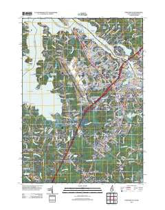
~ Portsmouth NH topo map, 1:24000 scale, 7.5 X 7.5 Minute, Historical, 2012
Portsmouth, New Hampshire, USGS topographic map dated 2012.
Includes geographic coordinates (latitude and longitude). This topographic map is suitable for hiking, camping, and exploring, or framing it as a wall map.
Printed on-demand using high resolution imagery, on heavy weight and acid free paper, or alternatively on a variety of synthetic materials.
Topos available on paper, Waterproof, Poly, or Tyvek. Usually shipping rolled, unless combined with other folded maps in one order.
- Product Number: USGS-5645139
- Free digital map download (high-resolution, GeoPDF): Portsmouth, New Hampshire (file size: 20 MB)
- Map Size: please refer to the dimensions of the GeoPDF map above
- Weight (paper map): ca. 55 grams
- Map Type: POD USGS Topographic Map
- Map Series: US Topo
- Map Verison: Historical
- Cell ID: 36128
- Datum: North American Datum of 1983
- Map Projection: Transverse Mercator
- Map Cell Name: Portsmouth
- Grid size: 7.5 X 7.5 Minute
- Date on map: 2012
- Map Scale: 1:24000
- Geographical region: New Hampshire, United States
Neighboring Maps:
All neighboring USGS topo maps are available for sale online at a variety of scales.
Spatial coverage:
Topo map Portsmouth, New Hampshire, covers the geographical area associated the following places:
- Newington Station - Elwyn Park - Green Acre - Puddle Dock (historical) - Winnicut Mills - Creek Area - Oak Terrace - Pannaway Manor - Breakfast Hill - Wentworth Acres - Portsmouth Mobile Homes - Acorn Acres - Piscataqua - Langs Corner - Greenland Station - Camp Gundalow - South Eliot - Christian Shore - Wentworth Terrace - Colonial Pines - Maplehaven - Bersum Gardens - Atlantic Heights - South Newington - Portsmouth - Newington - Seacrest Village - West Rye - Portsmouth Plains - Meadowbrook - Hillcrest Estates - Bayside - Tobeys Corner - Greenland - Rye
- Map Area ID: AREA43.12543-70.875-70.75
- Northwest corner Lat/Long code: USGSNW43.125-70.875
- Northeast corner Lat/Long code: USGSNE43.125-70.75
- Southwest corner Lat/Long code: USGSSW43-70.875
- Southeast corner Lat/Long code: USGSSE43-70.75
- Northern map edge Latitude: 43.125
- Southern map edge Latitude: 43
- Western map edge Longitude: -70.875
- Eastern map edge Longitude: -70.75