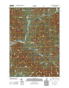
~ Mount Osceola NH topo map, 1:24000 scale, 7.5 X 7.5 Minute, Historical, 2012
Mount Osceola, New Hampshire, USGS topographic map dated 2012.
Includes geographic coordinates (latitude and longitude). This topographic map is suitable for hiking, camping, and exploring, or framing it as a wall map.
Printed on-demand using high resolution imagery, on heavy weight and acid free paper, or alternatively on a variety of synthetic materials.
Topos available on paper, Waterproof, Poly, or Tyvek. Usually shipping rolled, unless combined with other folded maps in one order.
- Product Number: USGS-5642570
- Free digital map download (high-resolution, GeoPDF): Mount Osceola, New Hampshire (file size: 24 MB)
- Map Size: please refer to the dimensions of the GeoPDF map above
- Weight (paper map): ca. 55 grams
- Map Type: POD USGS Topographic Map
- Map Series: US Topo
- Map Verison: Historical
- Cell ID: 30742
- Datum: North American Datum of 1983
- Map Projection: Transverse Mercator
- Map Cell Name: Mount Osceola
- Grid size: 7.5 X 7.5 Minute
- Date on map: 2012
- Map Scale: 1:24000
- Geographical region: New Hampshire, United States
Neighboring Maps:
All neighboring USGS topo maps are available for sale online at a variety of scales.
Spatial coverage:
Topo map Mount Osceola, New Hampshire, covers the geographical area associated the following places:
- Ice Pond - Franconia Brook Campsite - East Pond Trail - Whaleback Mountain - Wilderness Trail - Big Rock Campground - Birch Island Brook - Greeley Ponds Scenic Area - North Fork East Branch Pemigewasset River - Greeley Ponds - Hancock Overlook - Little East Pond Trail - Mount Hitchcock - Town of Lincoln - North Fork Hancock Branch - East Peak - Mount Osceola - Hancock Campground - Hancock Loop Trail - Hancock Branch - Cheney Brook - Black Pond - South Fork Hancock Branch - North Peak - Mount Osceola Trail - Franconia Shelter - Franconia Branch - Ceder Brook Trail - Scar Ridge - Greeley Ponds Trail - Osseo Trail - Black Brook - West Peak - Otter Rocks Rest Area - Clear Brook - Little East Pond - Cedar Brook - Franconia Falls - Mad River Notch - East Pond - East Pond Loop - Camp 16 Shelter - Camp 9 Shelter - Potash Knob - Black Mountain - Camp Nine Shelter - Hancock Campground - Lincoln Brook - Pine Brook
- Map Area ID: AREA44.12544-71.625-71.5
- Northwest corner Lat/Long code: USGSNW44.125-71.625
- Northeast corner Lat/Long code: USGSNE44.125-71.5
- Southwest corner Lat/Long code: USGSSW44-71.625
- Southeast corner Lat/Long code: USGSSE44-71.5
- Northern map edge Latitude: 44.125
- Southern map edge Latitude: 44
- Western map edge Longitude: -71.625
- Eastern map edge Longitude: -71.5