
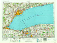
~ Toronto NY topo map, 1:250000 scale, 1 X 2 Degree, Historical, 1965
Toronto, New York, USGS topographic map dated 1965.
Includes geographic coordinates (latitude and longitude). This topographic map is suitable for hiking, camping, and exploring, or framing it as a wall map.
Printed on-demand using high resolution imagery, on heavy weight and acid free paper, or alternatively on a variety of synthetic materials.
Topos available on paper, Waterproof, Poly, or Tyvek. Usually shipping rolled, unless combined with other folded maps in one order.
- Product Number: USGS-5631285
- Free digital map download (high-resolution, GeoPDF): Toronto, New York (file size: 17 MB)
- Map Size: please refer to the dimensions of the GeoPDF map above
- Weight (paper map): ca. 55 grams
- Map Type: POD USGS Topographic Map
- Map Series: HTMC
- Map Verison: Historical
- Cell ID: 69056
- Scan ID: 139351
- Woodland Tint: Yes
- Survey Year: 1962
- Datum: Unstated
- Map Projection: Transverse Mercator
- Map published by United States Geological Survey
- Map Language: English
- Scanner Resolution: 600 dpi
- Map Cell Name: Toronto
- Grid size: 1 X 2 Degree
- Date on map: 1965
- Map Scale: 1:250000
- Geographical region: New York, United States
Neighboring Maps:
All neighboring USGS topo maps are available for sale online at a variety of scales.
Spatial coverage:
Topo map Toronto, New York, covers the geographical area associated the following places:
- Hickory Corners - Terrys Corners - Millville - Rapids Mobile Home Park - Cookville - Burt - Sunset Beach - Indian Falls - Wolcottsville - Lockport - Edgewater - North Forest Acres - Bushville - Hunts Corners - West Kendall - Dysinger - North Ridgeway - Country Meadows - La Salle - Streeters Corners - Platten - Gilberts Corner - Youngstown Estates - Morganville - Jones Beach - Saint Johnsburg - North Ridge - Five Corners - Heritage Estates - East Wilson - Kendall - Burma Woods - McNalls - West Alabama - Yates Center - Wurlitzer Park Village - Lakeside - Appleton - Rumsey Ridge - Shawnee - Barre Center - Akron - Pletchers Corners - Model City - Warrens Corners - Olcott - Gaines - Byron - Countryside Homes Mobile Home Park - Clarendon - Collingwood Estates - Oakfield - Wheatville - West Bergen - Pendleton Center - Ridgelea Heights - Suburban Acres Mobile Home Park - Old Mill Mobile Home Park - Thomas Estates West - South Byron - Swifts Mills - North Bergen - Highland Park - Bennetts Corners - Daws - Albion - West Shelby - Orangeport - Raymond - Youngstown - East Amherst - Riverside Manors - South Lockport - Tryonville - Nashville - Hinsburg - Expressway Village Mobile Home Park - Apple Grove Mobile Home Park - Walmore - Applewood Mobile Home Estates - Five Corners - Glenwood - Waterport Station - Hess Road - Baldwin Corner - Bergholtz - Sandy Beach - Basom - East Elba - Somerset - Mapleton - Lomond Shore - Eagle Harbor - Honest Hill - Green Acres Valley - Dreamland Mobile Home Park - North Hartland - Kent - Shelby Basin - Ransomville
- Map Area ID: AREA4443-80-78
- Northwest corner Lat/Long code: USGSNW44-80
- Northeast corner Lat/Long code: USGSNE44-78
- Southwest corner Lat/Long code: USGSSW43-80
- Southeast corner Lat/Long code: USGSSE43-78
- Northern map edge Latitude: 44
- Southern map edge Latitude: 43
- Western map edge Longitude: -80
- Eastern map edge Longitude: -78


