
~ Kingston NY topo map, 1:250000 scale, 1 X 2 Degree, Historical, 1954, updated 1968
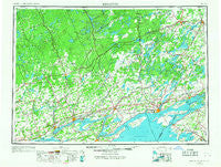
Kingston, New York, USGS topographic map dated 1954.
Includes geographic coordinates (latitude and longitude). This topographic map is suitable for hiking, camping, and exploring, or framing it as a wall map.
Printed on-demand using high resolution imagery, on heavy weight and acid free paper, or alternatively on a variety of synthetic materials.
Topos available on paper, Waterproof, Poly, or Tyvek. Usually shipping rolled, unless combined with other folded maps in one order.
- Product Number: USGS-5631265
- Free digital map download (high-resolution, GeoPDF): Kingston, New York (file size: 16 MB)
- Map Size: please refer to the dimensions of the GeoPDF map above
- Weight (paper map): ca. 55 grams
- Map Type: POD USGS Topographic Map
- Map Series: HTMC
- Map Verison: Historical
- Cell ID: 68858
- Scan ID: 130136
- Imprint Year: 1968
- Woodland Tint: Yes
- Visual Version Number: 1
- Edit Year: 1967
- Datum: Unstated
- Map Projection: Transverse Mercator
- Map published by United States Army Corps of Engineers
- Map published by United States Army
- Map Language: English
- Scanner Resolution: 600 dpi
- Map Cell Name: Kingston
- Grid size: 1 X 2 Degree
- Date on map: 1954
- Map Scale: 1:250000
- Geographical region: New York, United States
Neighboring Maps:
All neighboring USGS topo maps are available for sale online at a variety of scales.
Spatial coverage:
Topo map Kingston, New York, covers the geographical area associated the following places:
- Breezy Knoll Mobile Home Park - Dexter - Grindstone - Clayton Center - Bayview - Warren - Point Peninsula - Frontenac - Sunnybank - Fishers Landing - Lazy Acres Mobile Home Park - Lower Town Landing - Adams Cove - Clayton - Green Cedars Trailer Park - Saint Lawrence - Millen Bay - Upper Town Landing - Sunset Trailer Park - Perch River - Thousand Island Park - Cape Vincent - Rainbow Shores Mobile Home Park - Grandview Park - Shady Bay Mobile Home Park - Limerick - Herrick Grove - Grenell - Chaumont - Depauville - Rosiere - Reynolds Corner - Fineview - Lawrence View Mobile Home Park - Le Petite Ciel Mobile Home Park - Three Mile Bay
- Map Area ID: AREA4544-78-76
- Northwest corner Lat/Long code: USGSNW45-78
- Northeast corner Lat/Long code: USGSNE45-76
- Southwest corner Lat/Long code: USGSSW44-78
- Southeast corner Lat/Long code: USGSSE44-76
- Northern map edge Latitude: 45
- Southern map edge Latitude: 44
- Western map edge Longitude: -78
- Eastern map edge Longitude: -76


