~ Keene NH topo map, 1:100000 scale, 30 X 60 Minute, Historical, 1986, updated 1988
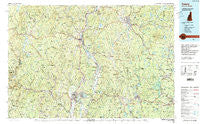
Keene, New Hampshire, USGS topographic map dated 1986.
Includes geographic coordinates (latitude and longitude). This topographic map is suitable for hiking, camping, and exploring, or framing it as a wall map.
Printed on-demand using high resolution imagery, on heavy weight and acid free paper, or alternatively on a variety of synthetic materials.
Topos available on paper, Waterproof, Poly, or Tyvek. Usually shipping rolled, unless combined with other folded maps in one order.
- Product Number: USGS-5583978
- Free digital map download (high-resolution, GeoPDF): Keene, New Hampshire (file size: 33 MB)
- Map Size: please refer to the dimensions of the GeoPDF map above
- Weight (paper map): ca. 55 grams
- Map Type: POD USGS Topographic Map
- Map Series: HTMC
- Map Verison: Historical
- Cell ID: 67752
- Scan ID: 330407
- Imprint Year: 1988
- Woodland Tint: Yes
- Visual Version Number: 1
- Aerial Photo Year: 1983
- Edit Year: 1986
- Datum: NAD27
- Map Projection: Universal Transverse Mercator
- Map published by United States Geological Survey
- Map Language: English
- Scanner Resolution: 600 dpi
- Map Cell Name: Keene
- Grid size: 30 X 60 Minute
- Date on map: 1986
- Map Scale: 1:100000
- Geographical region: New Hampshire, United States
Neighboring Maps:
All neighboring USGS topo maps are available for sale online at a variety of scales.
Spatial coverage:
Topo map Keene, New Hampshire, covers the geographical area associated the following places:
- West Dummerston - Longmeadow Subdivision - Brier - Satans Kingdom - Stoneville - West Brattleboro - Shattuckville - Hales Crossing - Lake Pleasant - South Athol - East Sullivan - Thomas - Dell - Troy - Goulding Village - East Templeton - Winchendon - North Vernon - Curtis Corner - Millers Falls - Montague City - Camp Forest Lake - West Chesterfield - Rindge - Harrisville - Turners Falls - South Ashfield - Dublin - Bernardston - North Richmond - East Westmoreland - Spragueville - South Hawley - Orange - Wendell - Pequoig - North Hinsdale - Packard Heights - South Royalston - Baldwinville - East Greenfield - Rowe - Factory Village (historical) - Eastview - Algiers (historical) - West Orange - Hoosac Tunnel - West Royalston - South Vernon - Neale Place - Grove - Fairview Village - Jacksonville - Hawley - Phillipston - Harrisville - Poocham - Scotland - Buckland - South Newfane - Brooks Village - Erving - Waterville - Cheapside - Rand - Locks Village - Fryeville - Green River - Hoosac Tunnel Station - Mount Hermon Station - South Wendell - Sky Farm - West Swanzey - Somerset - Buckland Four Corners - Colrain - Ames Hill - East Northfield Station - Morse Village - Whitneyville - Dodge Corner - Brattleboro - Vernon - Adamsville - New Salem - Tanglewood Estates - Mill River - Medburyville - Reid Hollow - Keene - Gill - Roxbury Center - Hydeville - Burkville - Templeton Station - Watson - Shelburne Falls - Zoar - Stewartville - Marlboro
- Map Area ID: AREA4342.5-73-72
- Northwest corner Lat/Long code: USGSNW43-73
- Northeast corner Lat/Long code: USGSNE43-72
- Southwest corner Lat/Long code: USGSSW42.5-73
- Southeast corner Lat/Long code: USGSSE42.5-72
- Northern map edge Latitude: 43
- Southern map edge Latitude: 42.5
- Western map edge Longitude: -73
- Eastern map edge Longitude: -72