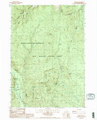
~ Stairs Mountain NH topo map, 1:24000 scale, 7.5 X 7.5 Minute, Historical, 1987, updated 1987
Stairs Mountain, New Hampshire, USGS topographic map dated 1987.
Includes geographic coordinates (latitude and longitude). This topographic map is suitable for hiking, camping, and exploring, or framing it as a wall map.
Printed on-demand using high resolution imagery, on heavy weight and acid free paper, or alternatively on a variety of synthetic materials.
Topos available on paper, Waterproof, Poly, or Tyvek. Usually shipping rolled, unless combined with other folded maps in one order.
- Product Number: USGS-5582888
- Free digital map download (high-resolution, GeoPDF): Stairs Mountain, New Hampshire (file size: 15 MB)
- Map Size: please refer to the dimensions of the GeoPDF map above
- Weight (paper map): ca. 55 grams
- Map Type: POD USGS Topographic Map
- Map Series: HTMC
- Map Verison: Historical
- Cell ID: 42829
- Scan ID: 329802
- Imprint Year: 1987
- Woodland Tint: Yes
- Visual Version Number: 1
- Aerial Photo Year: 1981
- Edit Year: 1987
- Field Check Year: 1983
- Datum: NAD27
- Map Projection: Transverse Mercator
- Provisional map: Yes
- Map published by United States Geological Survey
- Map Language: English
- Scanner Resolution: 600 dpi
- Map Cell Name: Stairs Mountain
- Grid size: 7.5 X 7.5 Minute
- Date on map: 1987
- Map Scale: 1:24000
- Geographical region: New Hampshire, United States
Neighboring Maps:
All neighboring USGS topo maps are available for sale online at a variety of scales.
Spatial coverage:
Topo map Stairs Mountain, New Hampshire, covers the geographical area associated the following places:
- Maple Mountain - Desolation Pond - Edmands Path - Branch Ridge - Mount Pleasant Trail - Lost Pond - Stairs Mountain - Mount Davis - Otis Brook - Oakes Gulf - Shelter Number One - Shelter Number One - Rocky Branch Trail - Rocky Branch Number One WMNF Shelter - Gulf of Slides - Mount Clinton Trail - Stairs Col Trail - Willey House Post Office - Montalban Ridge - Presidential Range-Dry River Wilderness - Mount Parker Trail - Mount Eisenhower Trail - Mount Jackson - Isolation Trail - Dry River Trail - Bemis Brook - Davis Brook - Gulf Peak - Glen Boulder Trail - Mount Franklin - Mount Resolution - Glen Boulder - Shelter Number Two - Upper Stairs Brook - Town of Hart's Location - Engine Hill - Crawford Path - Rocky Branch Ridge - Miles Brook Trail - Sargents Purchase - Hadleys Purchase - Oakes Gulf Trail - Dry River - Dry River Campground - Cutts Grant - Mount Isolation - Presidential Range - Isolation Shelter - Stairs Brook Trail - Mount Crawford - Frankenstein Cliff - Mizpah Spring Hut - Dry River Camping Area - Lower Stairs Brook - Glen Ellis Falls Picnic Area - Shelter Number Two - Sleeper Brook - Davis Path - Mount Eisenhower - Crawford Notch - Glen Ellis Falls - Resolution Shelter - Mount Pierce - Glen Ellis Falls Scenic Area - Giant Stairs
- Map Area ID: AREA44.2544.125-71.375-71.25
- Northwest corner Lat/Long code: USGSNW44.25-71.375
- Northeast corner Lat/Long code: USGSNE44.25-71.25
- Southwest corner Lat/Long code: USGSSW44.125-71.375
- Southeast corner Lat/Long code: USGSSE44.125-71.25
- Northern map edge Latitude: 44.25
- Southern map edge Latitude: 44.125
- Western map edge Longitude: -71.375
- Eastern map edge Longitude: -71.25