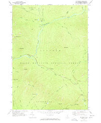
~ Mt Osceola NH topo map, 1:24000 scale, 7.5 X 7.5 Minute, Historical, 1967, updated 1972
Mt Osceola, New Hampshire, USGS topographic map dated 1967.
Includes geographic coordinates (latitude and longitude). This topographic map is suitable for hiking, camping, and exploring, or framing it as a wall map.
Printed on-demand using high resolution imagery, on heavy weight and acid free paper, or alternatively on a variety of synthetic materials.
Topos available on paper, Waterproof, Poly, or Tyvek. Usually shipping rolled, unless combined with other folded maps in one order.
- Product Number: USGS-5582674
- Free digital map download (high-resolution, GeoPDF): Mt Osceola, New Hampshire (file size: 11 MB)
- Map Size: please refer to the dimensions of the GeoPDF map above
- Weight (paper map): ca. 55 grams
- Map Type: POD USGS Topographic Map
- Map Series: HTMC
- Map Verison: Historical
- Cell ID: 30742
- Scan ID: 329692
- Imprint Year: 1972
- Woodland Tint: Yes
- Visual Version Number: 1
- Aerial Photo Year: 1964
- Field Check Year: 1967
- Datum: NAD27
- Map Projection: Polyconic
- Map published by United States Geological Survey
- Map Language: English
- Scanner Resolution: 600 dpi
- Map Cell Name: Mount Osceola
- Grid size: 7.5 X 7.5 Minute
- Date on map: 1967
- Map Scale: 1:24000
- Geographical region: New Hampshire, United States
Neighboring Maps:
All neighboring USGS topo maps are available for sale online at a variety of scales.
Spatial coverage:
Topo map Mt Osceola, New Hampshire, covers the geographical area associated the following places:
- Greeley Ponds - East Peak - Black Pond - Mad River Notch - Ceder Brook Trail - Town of Lincoln - Little East Pond Trail - Hancock Loop Trail - Hancock Campground - Lincoln Brook - Camp 9 Shelter - Potash Knob - Hancock Overlook - North Fork Hancock Branch - West Peak - Pine Brook - Franconia Shelter - Black Brook - Franconia Branch - Otter Rocks Rest Area - North Peak - Scar Ridge - Franconia Brook Campsite - Greeley Ponds Trail - Camp Nine Shelter - Mount Hitchcock - Franconia Falls - Big Rock Campground - Ice Pond - Little East Pond - Black Mountain - Cheney Brook - East Pond Trail - North Fork East Branch Pemigewasset River - Osseo Trail - Camp 16 Shelter - East Pond Loop - Mount Osceola - Hancock Campground - Greeley Ponds Scenic Area - Whaleback Mountain - Clear Brook - South Fork Hancock Branch - Hancock Branch - Birch Island Brook - Cedar Brook - East Pond - Mount Osceola Trail - Wilderness Trail
- Map Area ID: AREA44.12544-71.625-71.5
- Northwest corner Lat/Long code: USGSNW44.125-71.625
- Northeast corner Lat/Long code: USGSNE44.125-71.5
- Southwest corner Lat/Long code: USGSSW44-71.625
- Southeast corner Lat/Long code: USGSSE44-71.5
- Northern map edge Latitude: 44.125
- Southern map edge Latitude: 44
- Western map edge Longitude: -71.625
- Eastern map edge Longitude: -71.5