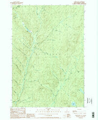
~ Cowen Hill NH topo map, 1:24000 scale, 7.5 X 7.5 Minute, Historical, 1989, updated 1989
Cowen Hill, New Hampshire, USGS topographic map dated 1989.
Includes geographic coordinates (latitude and longitude). This topographic map is suitable for hiking, camping, and exploring, or framing it as a wall map.
Printed on-demand using high resolution imagery, on heavy weight and acid free paper, or alternatively on a variety of synthetic materials.
Topos available on paper, Waterproof, Poly, or Tyvek. Usually shipping rolled, unless combined with other folded maps in one order.
- Product Number: USGS-5582332
- Free digital map download (high-resolution, GeoPDF): Cowen Hill, New Hampshire (file size: 14 MB)
- Map Size: please refer to the dimensions of the GeoPDF map above
- Weight (paper map): ca. 55 grams
- Map Type: POD USGS Topographic Map
- Map Series: HTMC
- Map Verison: Historical
- Cell ID: 10458
- Scan ID: 329514
- Imprint Year: 1989
- Woodland Tint: Yes
- Aerial Photo Year: 1984
- Edit Year: 1989
- Field Check Year: 1987
- Datum: NAD27
- Map Projection: Transverse Mercator
- Provisional map: Yes
- Map published by United States Geological Survey
- Map Language: English
- Scanner Resolution: 600 dpi
- Map Cell Name: Cowen Hill
- Grid size: 7.5 X 7.5 Minute
- Date on map: 1989
- Map Scale: 1:24000
- Geographical region: New Hampshire, United States
Neighboring Maps:
All neighboring USGS topo maps are available for sale online at a variety of scales.
Spatial coverage:
Topo map Cowen Hill, New Hampshire, covers the geographical area associated the following places:
- Round Pond - Depot Camp - Lamb Valley - Roaring Brook - Leighton Brook - Coon Brook Bog - Varney Camp (historical) - East Branch Indian Stream - Day Brook - Holden Camp - Trestle Brook - West Branch of Indian Stream Reservoir - Peterson Brook - Woods Brook - Teapot Brook - No Name Brook - Cowen Hill Camp - Dube Brook - Otter Brook - Abbott Brook - Perry Brook - West Branch Indian Stream - Greeley Brook - Falkenham Camp (historical) - Cascade Brook - Middle Branch Indian Stream - Cowen Hill - Moose Brook - Lamb Valley Brook - Runcourt Brook - Town of Pittsburg - Covell Mountain - Terrell Pond - Jobbers Brook - Klondyke Camp (historical) - Pearley Terrill Dam - Alder Brook - Graham Brook - Falkenham Brook - Schoppe Brook
- Map Area ID: AREA45.2545.125-71.375-71.25
- Northwest corner Lat/Long code: USGSNW45.25-71.375
- Northeast corner Lat/Long code: USGSNE45.25-71.25
- Southwest corner Lat/Long code: USGSSW45.125-71.375
- Southeast corner Lat/Long code: USGSSE45.125-71.25
- Northern map edge Latitude: 45.25
- Southern map edge Latitude: 45.125
- Western map edge Longitude: -71.375
- Eastern map edge Longitude: -71.25