
~ Walker Lake NV topo map, 1:250000 scale, 1 X 2 Degree, Historical, 1962, updated 1962
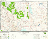
Walker Lake, Nevada, USGS topographic map dated 1962.
Includes geographic coordinates (latitude and longitude). This topographic map is suitable for hiking, camping, and exploring, or framing it as a wall map.
Printed on-demand using high resolution imagery, on heavy weight and acid free paper, or alternatively on a variety of synthetic materials.
Topos available on paper, Waterproof, Poly, or Tyvek. Usually shipping rolled, unless combined with other folded maps in one order.
- Product Number: USGS-5573884
- Free digital map download (high-resolution, GeoPDF): Walker Lake, Nevada (file size: 14 MB)
- Map Size: please refer to the dimensions of the GeoPDF map above
- Weight (paper map): ca. 55 grams
- Map Type: POD USGS Topographic Map
- Map Series: HTMC
- Map Verison: Historical
- Cell ID: 74994
- Scan ID: 321796
- Imprint Year: 1962
- Woodland Tint: Yes
- Aerial Photo Year: 1945
- Datum: NAD27
- Map Projection: Transverse Mercator
- Map published by United States Geological Survey
- Map Language: English
- Scanner Resolution: 600 dpi
- Map Cell Name: Walker Lake
- Grid size: 1 X 2 Degree
- Date on map: 1962
- Map Scale: 1:250000
- Geographical region: Nevada, United States
Neighboring Maps:
All neighboring USGS topo maps are available for sale online at a variety of scales.
Spatial coverage:
Topo map Walker Lake, Nevada, covers the geographical area associated the following places:
- Dunderberg Mill - Mesa Vista - Bridgeport - Carman Heights - Twelvemile House - Lundy - Fountain Place - Granite (historical) - Nordyke - Upper Town - Loope - Tahoe Village - Copperfield (historical) - Tonopah Junction - Hoye (historical) - Stateline - Topaz - Kennedy Meadow - Bodie - Lower Town - Cambridge (historical) - Columbus - Schurz - Basalt - Copper Hill (historical) - Jaggersville - Paynesville - Bijou Park - Mammoth Ledge (historical) - Luning - Chinatown - Walleys Hot Springs - Summit Village - Metallic City (historical) - Marietta - Mottsville - Acme (historical) - Cow Creek - Schweer Housing Area - Mina - Wellington - Dardanelle - Montelle (historical) - Holbrook Junction - Edgewood - Artesia (historical) - Shay Creek Summer Home Area - Walker River (historical) - Coleville - Del Monte - Garfield (historical) - Candelaria (historical) - Candelaria Junction - Woodfords - Round Hill - Hudson (historical) - Buckskin (historical) - Fales Hot Springs - Mountain View (historical) - Peaceful Pines - Elk Point - Centerville - Dog Town - Fredericksburg - Stateline - Mono City - Kingsbury Meadows - Walker - Mountain House (historical) - Fletcher - Sheridan - Alpine Village - Yerington - Mount Bullion (historical) - Kinkaid - Gardnerville Ranchos - Belfort - Dutch Creek (historical) - Whiskey Spring (historical) - Gardnerville - Bijou - Buckeye - Midway - Buckley Camp (historical) - Pine Grove - Sonora Junction - Aurora (historical) - Mason - Babbitt - Coryville (historical) - New Boston (historical) - Centerville (historical) - Camp Douglas - Tippecanoe (historical) - Weed Heights - Copper Run - Silver Mountain (historical) - Woodruffs (historical) - Kingsbury Village - Al Tahoe
- Map Area ID: AREA3938-120-118
- Northwest corner Lat/Long code: USGSNW39-120
- Northeast corner Lat/Long code: USGSNE39-118
- Southwest corner Lat/Long code: USGSSW38-120
- Southeast corner Lat/Long code: USGSSE38-118
- Northern map edge Latitude: 39
- Southern map edge Latitude: 38
- Western map edge Longitude: -120
- Eastern map edge Longitude: -118


