
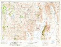
~ Vya NV topo map, 1:250000 scale, 1 X 2 Degree, Historical, 1962, updated 1962
Vya, Nevada, USGS topographic map dated 1962.
Includes geographic coordinates (latitude and longitude). This topographic map is suitable for hiking, camping, and exploring, or framing it as a wall map.
Printed on-demand using high resolution imagery, on heavy weight and acid free paper, or alternatively on a variety of synthetic materials.
Topos available on paper, Waterproof, Poly, or Tyvek. Usually shipping rolled, unless combined with other folded maps in one order.
- Product Number: USGS-5573876
- Free digital map download (high-resolution, GeoPDF): Vya, Nevada (file size: 18 MB)
- Map Size: please refer to the dimensions of the GeoPDF map above
- Weight (paper map): ca. 55 grams
- Map Type: POD USGS Topographic Map
- Map Series: HTMC
- Map Verison: Historical
- Cell ID: 75010
- Scan ID: 321792
- Imprint Year: 1962
- Woodland Tint: Yes
- Aerial Photo Year: 1954
- Edit Year: 1961
- Field Check Year: 1954
- Datum: Unstated
- Map Projection: Transverse Mercator
- Map published by United States Geological Survey
- Map published by United States Army Corps of Engineers
- Map published by United States Army
- Map Language: English
- Scanner Resolution: 600 dpi
- Map Cell Name: Vya
- Grid size: 1 X 2 Degree
- Date on map: 1962
- Map Scale: 1:250000
- Geographical region: Nevada, United States
Neighboring Maps:
All neighboring USGS topo maps are available for sale online at a variety of scales.
Spatial coverage:
Topo map Vya, Nevada, covers the geographical area associated the following places:
- Red Butte (historical) - Varyville (historical) - Andys Place - Wimer Place - Denio - Raiser City (historical) - Happy Creek Station - Quinn River Crossing - Diessner (historical) - Dyke - Overton (historical) - Swedes Place - Vya - Reederville - Denio Junction - Beulah (historical)
- Map Area ID: AREA4241-120-118
- Northwest corner Lat/Long code: USGSNW42-120
- Northeast corner Lat/Long code: USGSNE42-118
- Southwest corner Lat/Long code: USGSSW41-120
- Southeast corner Lat/Long code: USGSSE41-118
- Northern map edge Latitude: 42
- Southern map edge Latitude: 41
- Western map edge Longitude: -120
- Eastern map edge Longitude: -118


