
~ Elko NV topo map, 1:250000 scale, 1 X 2 Degree, Historical, 1965, updated 1965
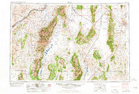
Elko, Nevada, USGS topographic map dated 1965.
Includes geographic coordinates (latitude and longitude). This topographic map is suitable for hiking, camping, and exploring, or framing it as a wall map.
Printed on-demand using high resolution imagery, on heavy weight and acid free paper, or alternatively on a variety of synthetic materials.
Topos available on paper, Waterproof, Poly, or Tyvek. Usually shipping rolled, unless combined with other folded maps in one order.
- Product Number: USGS-5573748
- Free digital map download (high-resolution, GeoPDF): Elko, Nevada (file size: 20 MB)
- Map Size: please refer to the dimensions of the GeoPDF map above
- Weight (paper map): ca. 55 grams
- Map Type: POD USGS Topographic Map
- Map Series: HTMC
- Map Verison: Historical
- Cell ID: 68765
- Scan ID: 321663
- Imprint Year: 1965
- Woodland Tint: Yes
- Aerial Photo Year: 1954
- Edit Year: 1962
- Field Check Year: 1955
- Datum: Unstated
- Map Projection: Transverse Mercator
- Map published by United States Geological Survey
- Map published by United States Army Corps of Engineers
- Map published by United States Army
- Map Language: English
- Scanner Resolution: 600 dpi
- Map Cell Name: Elko
- Grid size: 1 X 2 Degree
- Date on map: 1965
- Map Scale: 1:250000
- Geographical region: Nevada, United States
Neighboring Maps:
All neighboring USGS topo maps are available for sale online at a variety of scales.
Spatial coverage:
Topo map Elko, Nevada, covers the geographical area associated the following places:
- Bullion - Pleasant Valley - Ola - Elaine (historical) - Dolly Varden - Ventosa - Mizpah - Shanty Town - Eastline - Osino - Coin - Schley (historical) - Ballous Addition - Brennen Ranch - Fair Play (historical) - Highland (historical) - Sage - Secret (historical) - Sherman (historical) - Silver Zone - Arthur - Proctor - Hunter - Tobar (historical) - Broadway (historical) - Ryndon - Huntington (historical) - Dry Creek - Cavecreek (historical) - Goshute (historical) - Clifside - Ruby Valley - Jiggs - Lamoille - Black Forest (historical) - West Wendover - Halleck - Lee - Greens - Coral Hill (historical) - Sprucemont - Pilot - Wood (historical) - Decoy - Hobson (historical) - Corwin - Old Bullion - Cottonwood (historical) - Rock House - Hogan - Voight (historical) - Warm Creek (historical) - Currie - Shafter - Spring Creek - Moleen - Spruce - Elko - Wendover - Clover (historical) - Elburz
- Map Area ID: AREA4140-116-114
- Northwest corner Lat/Long code: USGSNW41-116
- Northeast corner Lat/Long code: USGSNE41-114
- Southwest corner Lat/Long code: USGSSW40-116
- Southeast corner Lat/Long code: USGSSE40-114
- Northern map edge Latitude: 41
- Southern map edge Latitude: 40
- Western map edge Longitude: -116
- Eastern map edge Longitude: -114


