
~ Mount Jefferson NV topo map, 1:100000 scale, 30 X 60 Minute, Historical, 1978, updated 1978
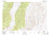
Mount Jefferson, Nevada, USGS topographic map dated 1978.
Includes geographic coordinates (latitude and longitude). This topographic map is suitable for hiking, camping, and exploring, or framing it as a wall map.
Printed on-demand using high resolution imagery, on heavy weight and acid free paper, or alternatively on a variety of synthetic materials.
Topos available on paper, Waterproof, Poly, or Tyvek. Usually shipping rolled, unless combined with other folded maps in one order.
- Product Number: USGS-5573548
- Free digital map download (high-resolution, GeoPDF): Mount Jefferson, Nevada (file size: 31 MB)
- Map Size: please refer to the dimensions of the GeoPDF map above
- Weight (paper map): ca. 55 grams
- Map Type: POD USGS Topographic Map
- Map Series: HTMC
- Map Verison: Historical
- Cell ID: 68001
- Scan ID: 321536
- Imprint Year: 1978
- Woodland Tint: Yes
- Aerial Photo Year: 1976
- Edit Year: 1978
- Datum: NAD27
- Map Projection: Universal Transverse Mercator
- Map published by United States Geological Survey
- Map Language: English
- Scanner Resolution: 600 dpi
- Map Cell Name: Mount Jefferson
- Grid size: 30 X 60 Minute
- Date on map: 1978
- Map Scale: 1:100000
- Geographical region: Nevada, United States
Neighboring Maps:
All neighboring USGS topo maps are available for sale online at a variety of scales.
Spatial coverage:
Topo map Mount Jefferson, Nevada, covers the geographical area associated the following places:
- Learville (historical) - Jefferson (historical) - San Pedros - Stargo (historical) - Northumberland (historical) - Belmont - Barcelona Summit - Danville (historical) - East Belmont (historical) - Stone House (historical) - Barcelona (historical) - Monarch (historical) - Lauville (historical) - Van Ness (historical) - Pioneer (historical) - Morey - Pine Creek (historical) - Pritchards Station - Flowers Camp - Antelope (historical) - Upper Town (historical) - Lower Town (historical)
- Map Area ID: AREA3938.5-117-116
- Northwest corner Lat/Long code: USGSNW39-117
- Northeast corner Lat/Long code: USGSNE39-116
- Southwest corner Lat/Long code: USGSSW38.5-117
- Southeast corner Lat/Long code: USGSSE38.5-116
- Northern map edge Latitude: 39
- Southern map edge Latitude: 38.5
- Western map edge Longitude: -117
- Eastern map edge Longitude: -116


