
~ Eugene Mts NV topo map, 1:100000 scale, 30 X 60 Minute, Historical, 1985, updated 1985
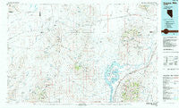
Eugene Mts, Nevada, USGS topographic map dated 1985.
Includes geographic coordinates (latitude and longitude). This topographic map is suitable for hiking, camping, and exploring, or framing it as a wall map.
Printed on-demand using high resolution imagery, on heavy weight and acid free paper, or alternatively on a variety of synthetic materials.
Topos available on paper, Waterproof, Poly, or Tyvek. Usually shipping rolled, unless combined with other folded maps in one order.
- Product Number: USGS-5573490
- Free digital map download (high-resolution, GeoPDF): Eugene Mts, Nevada (file size: 23 MB)
- Map Size: please refer to the dimensions of the GeoPDF map above
- Weight (paper map): ca. 55 grams
- Map Type: POD USGS Topographic Map
- Map Series: HTMC
- Map Verison: Historical
- Cell ID: 67490
- Scan ID: 321504
- Imprint Year: 1985
- Woodland Tint: Yes
- Visual Version Number: 1
- Aerial Photo Year: 1980
- Edit Year: 1985
- Datum: NAD27
- Map Projection: Universal Transverse Mercator
- Map published by United States Geological Survey
- Map Language: English
- Scanner Resolution: 600 dpi
- Map Cell Name: Eugene Mountains
- Grid size: 30 X 60 Minute
- Date on map: 1985
- Map Scale: 1:100000
- Geographical region: Nevada, United States
Neighboring Maps:
All neighboring USGS topo maps are available for sale online at a variety of scales.
Spatial coverage:
Topo map Eugene Mts, Nevada, covers the geographical area associated the following places:
- Lander City (historical) - Farrell (historical) - Humboldt City - Humboldt - Central (historical) - Venado (historical) - Neptune City (historical) - Cosgrave - Jungo (historical) - Mill City - Goldbud (historical) - Star City (historical) - Scossa - Twain - Poker Brown - Sulphur - Rosebud (historical) - Imlay - Tungsten - Pronto - Humboldt House - Raspberry Creek (historical) - Placerites
- Map Area ID: AREA4140.5-119-118
- Northwest corner Lat/Long code: USGSNW41-119
- Northeast corner Lat/Long code: USGSNE41-118
- Southwest corner Lat/Long code: USGSSW40.5-119
- Southeast corner Lat/Long code: USGSSE40.5-118
- Northern map edge Latitude: 41
- Southern map edge Latitude: 40.5
- Western map edge Longitude: -119
- Eastern map edge Longitude: -118


