
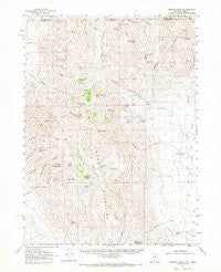
~ Trident Peak NV topo map, 1:62500 scale, 15 X 15 Minute, Historical, 1961, updated 1968
Trident Peak, Nevada, USGS topographic map dated 1961.
Includes geographic coordinates (latitude and longitude). This topographic map is suitable for hiking, camping, and exploring, or framing it as a wall map.
Printed on-demand using high resolution imagery, on heavy weight and acid free paper, or alternatively on a variety of synthetic materials.
Topos available on paper, Waterproof, Poly, or Tyvek. Usually shipping rolled, unless combined with other folded maps in one order.
- Product Number: USGS-5573310
- Free digital map download (high-resolution, GeoPDF): Trident Peak, Nevada (file size: 8 MB)
- Map Size: please refer to the dimensions of the GeoPDF map above
- Weight (paper map): ca. 55 grams
- Map Type: POD USGS Topographic Map
- Map Series: HTMC
- Map Verison: Historical
- Cell ID: 63683
- Scan ID: 321387
- Imprint Year: 1968
- Woodland Tint: Yes
- Aerial Photo Year: 1959
- Field Check Year: 1961
- Datum: NAD27
- Map Projection: Polyconic
- Map published by United States Geological Survey
- Map Language: English
- Scanner Resolution: 600 dpi
- Map Cell Name: Trident Peak
- Grid size: 15 X 15 Minute
- Date on map: 1961
- Map Scale: 1:62500
- Geographical region: Nevada, United States
Neighboring Maps:
All neighboring USGS topo maps are available for sale online at a variety of scales.
Spatial coverage:
Topo map Trident Peak, Nevada, covers the geographical area associated the following places:
- Rodeo Creek - Lucky Strike Mine - Miller Trough - Holloway Spring - Gartiez Spring - Shyster Spring - Miller Corral - Cherry Patch Spring - Cold Springs - Granite Mountain - China Creek - Jack Spade Cabin - Cold Springs Creek - Lovely Valley Spring - Slater Mine - Holloway Mountain - North Shyster Creek - Top Spring - North Branch Maggie Creek - Sisson Cabin - Dry Creek - Little Creek Spring - Black Canyon - Log Cabin - Upper Crow Creek Spring - Slatterly Cabin - Buster Springs - Maggie Creek Spring - Summit Spring - Raster Creek - Holloway Ridge - Rock Spring - Johnny Creek - Split Peak - Jensen Mine - Trident Peak - Etchart Springs - Fivemile Spring - Seep Spring - Black Diamond Peak - West Fork Granite Creek - Catlow Mine - Log Cabin Creek - Granite Mountain - House Creek - East Fork Granite Creek - Warm Spring - Agate Point - Butte Creek - South Shyster Creek - Kings River Ranch - Texas Springs - Shyster Butte - Crow Creek Spring - Ayers Cabin Ruins - Woodward Cabin - House Creek Butte - Little Sage Hen Spring - Center Spring - Little Creek - South Branch Maggie Creek - Granite Creek - Cherry Creek
- Map Area ID: AREA4241.75-118.5-118.25
- Northwest corner Lat/Long code: USGSNW42-118.5
- Northeast corner Lat/Long code: USGSNE42-118.25
- Southwest corner Lat/Long code: USGSSW41.75-118.5
- Southeast corner Lat/Long code: USGSSE41.75-118.25
- Northern map edge Latitude: 42
- Southern map edge Latitude: 41.75
- Western map edge Longitude: -118.5
- Eastern map edge Longitude: -118.25


