
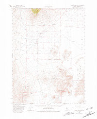
~ Donna Schee Peak NV topo map, 1:62500 scale, 15 X 15 Minute, Historical, 1966, updated 1981
Donna Schee Peak, Nevada, USGS topographic map dated 1966.
Includes geographic coordinates (latitude and longitude). This topographic map is suitable for hiking, camping, and exploring, or framing it as a wall map.
Printed on-demand using high resolution imagery, on heavy weight and acid free paper, or alternatively on a variety of synthetic materials.
Topos available on paper, Waterproof, Poly, or Tyvek. Usually shipping rolled, unless combined with other folded maps in one order.
- Product Number: USGS-5572448
- Free digital map download (high-resolution, GeoPDF): Donna Schee Peak, Nevada (file size: 6 MB)
- Map Size: please refer to the dimensions of the GeoPDF map above
- Weight (paper map): ca. 55 grams
- Map Type: POD USGS Topographic Map
- Map Series: HTMC
- Map Verison: Historical
- Cell ID: 53503
- Scan ID: 320867
- Imprint Year: 1981
- Woodland Tint: Yes
- Aerial Photo Year: 1965
- Field Check Year: 1966
- Datum: NAD27
- Map Projection: Polyconic
- Map published by United States Geological Survey
- Map Language: English
- Scanner Resolution: 600 dpi
- Map Cell Name: Donna Schee Peak
- Grid size: 15 X 15 Minute
- Date on map: 1966
- Map Scale: 1:62500
- Geographical region: Nevada, United States
Neighboring Maps:
All neighboring USGS topo maps are available for sale online at a variety of scales.
Spatial coverage:
Topo map Donna Schee Peak, Nevada, covers the geographical area associated the following places:
- Little Cedar Creek - Hardpans - Trout Creek Ranch - Boulder Creek - Bull Creek - Donna Schee Spring - Krug Hill - Post Creek - Jungo Hills - Big Cedar Creek - Shawnee Creek - Krug Mine - Noble Spring - Fivemile Well - McNinch Well - Bull Creek Ditch - Donna Schee Peak - Dry Hills - Trout Creek - Big Creek - Alexander Ranch - Willows Spring - Willow Creek Ranch - O'Brien Creek - Schoolhouse Butte - Sand Dunes Well - Clover Creek - Willow Creek - Louse Creek - Big Cedar Creek Ditch - Little Cedar Creek Ditch
- Map Area ID: AREA41.2541-118.5-118.25
- Northwest corner Lat/Long code: USGSNW41.25-118.5
- Northeast corner Lat/Long code: USGSNE41.25-118.25
- Southwest corner Lat/Long code: USGSSW41-118.5
- Southeast corner Lat/Long code: USGSSE41-118.25
- Northern map edge Latitude: 41.25
- Southern map edge Latitude: 41
- Western map edge Longitude: -118.5
- Eastern map edge Longitude: -118.25


