
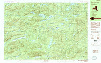
~ West Canada Lakes NY topo map, 1:25000 scale, 7.5 X 15 Minute, Historical, 1990
West Canada Lakes, New York, USGS topographic map dated 1990.
Includes geographic coordinates (latitude and longitude). This topographic map is suitable for hiking, camping, and exploring, or framing it as a wall map.
Printed on-demand using high resolution imagery, on heavy weight and acid free paper, or alternatively on a variety of synthetic materials.
Topos available on paper, Waterproof, Poly, or Tyvek. Usually shipping rolled, unless combined with other folded maps in one order.
- Product Number: USGS-5455241
- Free digital map download (high-resolution, GeoPDF): West Canada Lakes, New York (file size: 22 MB)
- Map Size: please refer to the dimensions of the GeoPDF map above
- Weight (paper map): ca. 55 grams
- Map Type: POD USGS Topographic Map
- Map Series: HTMC
- Map Verison: Historical
- Cell ID: 75703
- Scan ID: 137005
- Woodland Tint: Yes
- Visual Version Number: 2
- Aerial Photo Year: 1983
- Edit Year: 1990
- Field Check Year: 1986
- Datum: NAD27
- Map Projection: Universal Transverse Mercator
- Provisional map: Yes
- Map published by United States Geological Survey
- Map Language: English
- Scanner Resolution: 600 dpi
- Map Cell Name: West Canada Lakes
- Grid size: 7.5 X 15 Minute
- Date on map: 1990
- Map Scale: 1:25000
- Geographical region: New York, United States
Neighboring Maps:
All neighboring USGS topo maps are available for sale online at a variety of scales.
Spatial coverage:
Topo map West Canada Lakes, New York, covers the geographical area associated the following places:
- Muskrat Pond - Mud Lake - Otter Lake - Goose Lake - Mud Creek - Kings Pond - Wolf Creek - Big Brook - Deep Lake - Willis Mountain - Balsam Lake - Town of Arietta - Carter Mudhole - Stony Brook - Otter Lake - Cat Lake - Beaver Pond - Bullhead Pond - West Canada Mountain - Millers Camp - Bloodgood Brook - Cobble Hill - Little Moose Pond - Northrup Lake - Poor Lake - Whitney Creek - West Lake - Spruce Lake - Blue Ridge - Amos Lake - Pillsbury Bay - Cedar Lakes - Noisey Ridge - Dewitt Pond - Sampson Bog - Second Stillwater - Mica Lakes - South Lake - Pillsbury Mountain Forest Fire Observation Station - Belden Vly - Spruce Lake Mountain - Puddle Hole - Goodluck Mountain - West Canada Lakes - Brooktrout Lake - Pillsbury Mountain - Mitchell Dam - Twin Lakes - Whitney Lake - Sampson Lake - Noisey Inlet - Pillsbury Lake
- Map Area ID: AREA43.62543.5-74.75-74.5
- Northwest corner Lat/Long code: USGSNW43.625-74.75
- Northeast corner Lat/Long code: USGSNE43.625-74.5
- Southwest corner Lat/Long code: USGSSW43.5-74.75
- Southeast corner Lat/Long code: USGSSE43.5-74.5
- Northern map edge Latitude: 43.625
- Southern map edge Latitude: 43.5
- Western map edge Longitude: -74.75
- Eastern map edge Longitude: -74.5


