
~ Utica NY topo map, 1:250000 scale, 1 X 2 Degree, Historical, 1964, updated 1964
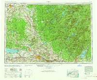
Utica, New York, USGS topographic map dated 1964.
Includes geographic coordinates (latitude and longitude). This topographic map is suitable for hiking, camping, and exploring, or framing it as a wall map.
Printed on-demand using high resolution imagery, on heavy weight and acid free paper, or alternatively on a variety of synthetic materials.
Topos available on paper, Waterproof, Poly, or Tyvek. Usually shipping rolled, unless combined with other folded maps in one order.
- Product Number: USGS-5454913
- Free digital map download (high-resolution, GeoPDF): Utica, New York (file size: 17 MB)
- Map Size: please refer to the dimensions of the GeoPDF map above
- Weight (paper map): ca. 55 grams
- Map Type: POD USGS Topographic Map
- Map Series: HTMC
- Map Verison: Historical
- Cell ID: 69076
- Scan ID: 139461
- Imprint Year: 1964
- Woodland Tint: Yes
- Aerial Photo Year: 1944
- Datum: NAD27
- Map Projection: Transverse Mercator
- Map published by United States Army Corps of Engineers
- Map published by United States Army
- Map Language: English
- Scanner Resolution: 600 dpi
- Map Cell Name: Utica
- Grid size: 1 X 2 Degree
- Date on map: 1964
- Map Scale: 1:250000
- Geographical region: New York, United States
Neighboring Maps:
All neighboring USGS topo maps are available for sale online at a variety of scales.
Spatial coverage:
Topo map Utica, New York, covers the geographical area associated the following places:
- McConnellsville - Bridgeport - Lotville - Talcottville - Brookside Manor - Gees Corner - Oneida Lake Beach West - Deerland - Hasbroucks - Blackmans Corners - Maple Hill - Nicholsville - Clockville - Ingham Mills Station - Tenantville - Sabael - West Amboy - Salisbury Center - Glendale - Hale Mills - Bolivar - East Frankfort - Wampsville - Liberty Gardens - Stokes Corner - Glenridge Mobile Home Park - Zoar - Sylvan Beach - Five Corners - Churchville - Florence Hill - Harrisburg - Eagle Bay - Old City - Riceville - Dempster Corners - Clarkville - Wheelerville - Swancott Mill - North Chittenango - Pudding Hollow - Tuxedo Mobile Home Park - Dumbarton - Fish Creek Station - Cleveland - Bradtville - Goulds Mill - Redmond Corner - Curtis - Sauquoit Mobile Home Park - Michigan Mills - Wright Settlement - Watertown - Humaston - Bleecker - Ilion - Oregon - Broadalbin - Leisher Mill - Delta Lake Trailer Court - Merrillsville - Barry's Mobile Home Park - Atwell - Gorthey Corners - Country Meadows Mobile Home Park - North Constantia - Aiden Lair - Bennetts Corners - Walesville - Wolf Lake Landing - Smiths Corners - Trenton Falls - Northwoods Club - Snyder Crossing - Grant - Hill Corners - Perryville - Camelot Village - Rockwood - Bull Hill - North Wilmurt - Girards Sugarbush - Glenfield - Kenwood - Collinsville - Otter Lake - Corrado Corners - Morehouseville - Shuetown - Page - Stoneybrook Mobile Terrace - Galway - Pine Meadows Mobile Home Park - Willow Place - Verona Mobile Home Park - Pine Hill - Hinckley - Ruback Camp - New Boston - Caroga Lake
- Map Area ID: AREA4443-76-74
- Northwest corner Lat/Long code: USGSNW44-76
- Northeast corner Lat/Long code: USGSNE44-74
- Southwest corner Lat/Long code: USGSSW43-76
- Southeast corner Lat/Long code: USGSSE43-74
- Northern map edge Latitude: 44
- Southern map edge Latitude: 43
- Western map edge Longitude: -76
- Eastern map edge Longitude: -74


