
~ Utica NY topo map, 1:250000 scale, 1 X 2 Degree, Historical, 1962, updated 1974
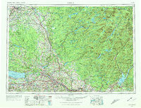
Utica, New York, USGS topographic map dated 1962.
Includes geographic coordinates (latitude and longitude). This topographic map is suitable for hiking, camping, and exploring, or framing it as a wall map.
Printed on-demand using high resolution imagery, on heavy weight and acid free paper, or alternatively on a variety of synthetic materials.
Topos available on paper, Waterproof, Poly, or Tyvek. Usually shipping rolled, unless combined with other folded maps in one order.
- Product Number: USGS-5454909
- Free digital map download (high-resolution, GeoPDF): Utica, New York (file size: 17 MB)
- Map Size: please refer to the dimensions of the GeoPDF map above
- Weight (paper map): ca. 55 grams
- Map Type: POD USGS Topographic Map
- Map Series: HTMC
- Map Verison: Historical
- Cell ID: 69076
- Scan ID: 139459
- Imprint Year: 1974
- Woodland Tint: Yes
- Visual Version Number: 1
- Field Check Year: 1962
- Datum: Unstated
- Map Projection: Transverse Mercator
- Map published by United States Army Corps of Engineers
- Map published by United States Army
- Map Language: English
- Scanner Resolution: 600 dpi
- Map Cell Name: Utica
- Grid size: 1 X 2 Degree
- Date on map: 1962
- Map Scale: 1:250000
- Geographical region: New York, United States
Neighboring Maps:
All neighboring USGS topo maps are available for sale online at a variety of scales.
Spatial coverage:
Topo map Utica, New York, covers the geographical area associated the following places:
- Hooker - Stairs Corners - Farrel Corner - Hurlbutville - Flint Town - Canastota - Walkers Corners - Sulphur Springs - Texas - Indian Castle - Durhamville - Messenger Bay - Lynch Tract - Paris - Shaker Place - East Creek - Riceville - Gloversville - Kecks Center - Ives Hollow - Fort Herkimer - Wilbers Mobile Home Park - Floyd - Tuxedo Mobile Home Park - Osceola - Stillwater - Point Rock - New Hartford - Woodland Estates Mobile Home Park - Sacandaga Meadows Mobile Home Park - Knappville - Rudeston - Lake View - Northwoods Club - Fink Basin - Eagle Village - Marcy - Cottons - Blue Mountain Lake - Edgebrook Mobile Home Park - Russia - Becks Grove - Croghan - Big Moose - Paradise Pines Mobile Home Park - Goodrich Corners - Herkimer Landing - Gulph - Delta Lake Trailer Court - North Constantia - Verona Beach - Evergreen Hills Mobile Home Community - Salisbury - Otter Lake - Breezy Acres Mobile Home Park - Five Corners - Johnson Corners - Mohawk - Dibbletown - Edinburg - Leisher Mill - Verona - Rockwood - Bolivar - Terrace Hill Mobile Home Estates - Constantia Center - Alder Creek - Red Carpet Mobile Home Park - Verona Mills - Stacy Basin - Sherrill - East Verona - Bartlett - Wells Corner - Dams Corner - Kirschnerville - Piseco - Deerland - Gravesville - Floral Estates Mobile Home Park - Grant - Cagwin Corners - Lakeport - Smartville - Hoseville - Saratogian Estates - Redfield - Canada Lake - Martinsburg - Corrado Corners - Ohio - Rutland Center - Bernhards Bay - Fairweather Corners - Mohawk Hill - Agnes Corners - Baker Corners - East Frankfort - Paradise Hill - Hemlock District
- Map Area ID: AREA4443-76-74
- Northwest corner Lat/Long code: USGSNW44-76
- Northeast corner Lat/Long code: USGSNE44-74
- Southwest corner Lat/Long code: USGSSW43-76
- Southeast corner Lat/Long code: USGSSE43-74
- Northern map edge Latitude: 44
- Southern map edge Latitude: 43
- Western map edge Longitude: -76
- Eastern map edge Longitude: -74


