
~ Rochester NY topo map, 1:250000 scale, 1 X 2 Degree, Historical, 1961, updated 1973
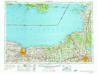
Rochester, New York, USGS topographic map dated 1961.
Includes geographic coordinates (latitude and longitude). This topographic map is suitable for hiking, camping, and exploring, or framing it as a wall map.
Printed on-demand using high resolution imagery, on heavy weight and acid free paper, or alternatively on a variety of synthetic materials.
Topos available on paper, Waterproof, Poly, or Tyvek. Usually shipping rolled, unless combined with other folded maps in one order.
- Product Number: USGS-5454895
- Free digital map download (high-resolution, GeoPDF): Rochester, New York (file size: 17 MB)
- Map Size: please refer to the dimensions of the GeoPDF map above
- Weight (paper map): ca. 55 grams
- Map Type: POD USGS Topographic Map
- Map Series: HTMC
- Map Verison: Historical
- Cell ID: 68989
- Scan ID: 136523
- Imprint Year: 1973
- Woodland Tint: Yes
- Visual Version Number: 1
- Field Check Year: 1961
- Datum: Unstated
- Map Projection: Transverse Mercator
- Map published by United States Geological Survey
- Map Language: English
- Scanner Resolution: 600 dpi
- Map Cell Name: Rochester
- Grid size: 1 X 2 Degree
- Date on map: 1961
- Map Scale: 1:250000
- Geographical region: New York, United States
Neighboring Maps:
All neighboring USGS topo maps are available for sale online at a variety of scales.
Spatial coverage:
Topo map Rochester, New York, covers the geographical area associated the following places:
- Furnace Village - Furniss - Cedar Swamp - Euclid - Pine Ridge Mobile Home Park - Lyon Corner - Lyndon Lawns Mobile Home Park - Clark Lane Mobile Home Park - Port Gibson - Loomis Corner - Blue Spruce Mobile Home Park - Zurich - Maiden Lane Mobile Home Park - Pulaski - Kendall Mills - Lindbergh Lawns - Riga - Shore Oaks - Wolcott - Boultons Beach - Cold Springs - Fox Ridge - Hilton - Drakes Corner - Toad Harbor - Prattham - Greece - Fawn Estates Mobile Home Park - Egypt - Sand Ridge - Town Pump - Moyers Corners - Severance - Farmington - Ridgeland - Pleasant Meadow Mobile Home Park - Brewerton - Barnard - Michael O'Brian's Mobile Home Park - Marengo - Arrowhead Mobile Home Park - Victory - Ionia - Brookdale - Bayberry - High Bridge - West Greece - Vermilion - Jones Point - Pineville - Rolling Hills Mobile Home Court - Hamlin - Stewart Corners - Valentines Beach - Sandy Creek - Sodus Point - Seneca Knolls - Lock Berlin - Martville - Bailey - Angells Corner - Idlewood On The Lake - Texas - Rochester - Pleasant Point Crossing - Lyndon - Orchard Grove Village Park - Tressmar - Pittsford - Braddock Heights - Rock Beach - The Kingdom (historical) - Peru - Caughdenoy - Ontario - Belgium - Amboy - Marion - Wiley Corner - Woodard - Mortimer - Sea Breeze - Williamson - Montario Point - Maple View - South Sodus - Jones Corners - West Shore Mobile Home Park - Doris Park - Hillcrest East Mobile Home Park - Adams Center - North Rose - Farmers Corner - Alton Mobile Home Park - Penfield Center - Fenner - Hinsdale - Brown Center - North Landing - Conifer Mobile Home Park
- Map Area ID: AREA4443-78-76
- Northwest corner Lat/Long code: USGSNW44-78
- Northeast corner Lat/Long code: USGSNE44-76
- Southwest corner Lat/Long code: USGSSW43-78
- Southeast corner Lat/Long code: USGSSE43-76
- Northern map edge Latitude: 44
- Southern map edge Latitude: 43
- Western map edge Longitude: -78
- Eastern map edge Longitude: -76


