
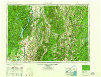
~ Glens Falls NY topo map, 1:250000 scale, 1 X 2 Degree, Historical, 1959, updated 1959
Glens Falls, New York, USGS topographic map dated 1959.
Includes geographic coordinates (latitude and longitude). This topographic map is suitable for hiking, camping, and exploring, or framing it as a wall map.
Printed on-demand using high resolution imagery, on heavy weight and acid free paper, or alternatively on a variety of synthetic materials.
Topos available on paper, Waterproof, Poly, or Tyvek. Usually shipping rolled, unless combined with other folded maps in one order.
- Product Number: USGS-5454851
- Free digital map download (high-resolution, GeoPDF): Glens Falls, New York (file size: 20 MB)
- Map Size: please refer to the dimensions of the GeoPDF map above
- Weight (paper map): ca. 55 grams
- Map Type: POD USGS Topographic Map
- Map Series: HTMC
- Map Verison: Historical
- Cell ID: 68797
- Scan ID: 129548
- Imprint Year: 1959
- Woodland Tint: Yes
- Visual Version Number: 1
- Aerial Photo Year: 1944
- Datum: NAD27
- Map Projection: Transverse Mercator
- Map published by United States Army Corps of Engineers
- Map published by United States Army
- Map published by: Military, Other
- Map Language: English
- Scanner Resolution: 600 dpi
- Map Cell Name: Glens Falls
- Grid size: 1 X 2 Degree
- Date on map: 1959
- Map Scale: 1:250000
- Geographical region: New York, United States
Neighboring Maps:
All neighboring USGS topo maps are available for sale online at a variety of scales.
Spatial coverage:
Topo map Glens Falls, New York, covers the geographical area associated the following places:
- Healdville - Stratton - Middletown - Coachman Estates - LeBruns Mobile Home Park - South Glens Falls - South Hartford - Minerva - Nelsons Corner - Battenville - The Island - Munsonville - Pawlet - West Tinmouth - Ely - Rawsonville - Spraguetown - Claremont Junction - Fernwood - Palmer - Regatta View - Gaysville - Landgrove Town Center - Schroon Lake - Barnard - Goulds Mill - Mannings Cove - Ashfords Way - Simonsville - West Wardsboro - West Bridport - Cornwall - East Clarendon - Chris Mobile Home Park - South Stoddard - East Wilder - Archdale - East Shoreham - Whitesville - East Lempster - North Bolton - East Middlebury - South Royalton - North Easton - Vershire Heights - Stratton Mountain - Bomoseen - Mascoma - Sheddsville - Adamsville - South Vershire - Dowdey Corner - Pruyn Crest - Hanover Center - Bald Mountain - Sharon - Athens - Orwell - Malta Ridge - Harmonyville - The Meadows - Westminster - Ryder Corner - Beacon Hill - Yaddo - Norwich - Braintree Hill - Pyramid Pines Mobile Home Park - Squag City - Clarks Corner - Felchville - Reynolds Corners - Cornish Flat - Shoreham - Hillsdale - West Hebron - Stonegate - West Springfield - Springfield Junction - Branch School (historical) - Mount Pleasant - Middle Granville - Snake Hill - Lost Valley Estates - Kingsbury - Balloch - Hammondsville - Birchton - Benson - Slateville - East Kansas - Sandgate - Washburn Corner - Mountain View Estates - Tinmouth - West Braintree - East Braintree - Riverbank - Athol - West Claremont
- Map Area ID: AREA4443-74-72
- Northwest corner Lat/Long code: USGSNW44-74
- Northeast corner Lat/Long code: USGSNE44-72
- Southwest corner Lat/Long code: USGSSW43-74
- Southeast corner Lat/Long code: USGSSE43-72
- Northern map edge Latitude: 44
- Southern map edge Latitude: 43
- Western map edge Longitude: -74
- Eastern map edge Longitude: -72


