
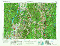
~ Glens Falls NY topo map, 1:250000 scale, 1 X 2 Degree, Historical, 1956, updated 1968
Glens Falls, New York, USGS topographic map dated 1956.
Includes geographic coordinates (latitude and longitude). This topographic map is suitable for hiking, camping, and exploring, or framing it as a wall map.
Printed on-demand using high resolution imagery, on heavy weight and acid free paper, or alternatively on a variety of synthetic materials.
Topos available on paper, Waterproof, Poly, or Tyvek. Usually shipping rolled, unless combined with other folded maps in one order.
- Product Number: USGS-5454849
- Free digital map download (high-resolution, GeoPDF): Glens Falls, New York (file size: 19 MB)
- Map Size: please refer to the dimensions of the GeoPDF map above
- Weight (paper map): ca. 55 grams
- Map Type: POD USGS Topographic Map
- Map Series: HTMC
- Map Verison: Historical
- Cell ID: 68797
- Scan ID: 129547
- Imprint Year: 1968
- Woodland Tint: Yes
- Visual Version Number: 1
- Photo Revision Year: 1967
- Edit Year: 1967
- Field Check Year: 1956
- Datum: Unstated
- Map Projection: Transverse Mercator
- Map published by United States Army Corps of Engineers
- Map published by United States Army
- Map Language: English
- Scanner Resolution: 600 dpi
- Map Cell Name: Glens Falls
- Grid size: 1 X 2 Degree
- Date on map: 1956
- Map Scale: 1:250000
- Geographical region: New York, United States
Neighboring Maps:
All neighboring USGS topo maps are available for sale online at a variety of scales.
Spatial coverage:
Topo map Glens Falls, New York, covers the geographical area associated the following places:
- Bellows Falls - Queensbury Village Mobile Home Park - Marlow Junction - Lower Village - West Lebanon - Brookline - Hortonville - Forest Dale - Healdville - West Braintree - Rochester - Paradox - Harmonyville - Jamaica - Jewell Corner - Crown Point Center - West Hebron - Fernwood - Hardscrabble Corner - West Corners - Sabbath Day Point - Middle Falls - South Reading - Factoryville - North Shrewsbury - Coveville - East Arlington - Ashfords Way - French Mountain - Colonial Estates - Centertown - Avalon Beach - Roundys Corner - Jerusalem - Dodge Hollow - East Lempster - Clarks Mills - Coachman Estates - Bourne Brook - Goshen - Jericho - Rices Mills - Village Estates Mobile Home Park - South Cornish - Crown Point - Eddy Corners - Castlewood - Oscars Mobile Home Park - Brayton - Daniel Corners Trailer Park - Fly Summit - Country Manor Trailer Court - East Hubbardton - Putnam Station - Ludlow - Fieldsville - Stocker Acres - Montcalm - Grafton - Manchester Depot - South Greenfield - Cornish Mills - South Pomfret - Athens - North Windham - Brockways Mills - Lower Village - Fort Ann - Blissville - Newbury - Guild - Neshobe Beach - Bradford - Hanover - North Hartland - Lake Sunnyside - Houghtonville - Crystal Beach - South Poultney - Bartonsville - South Woodstock - Regatta View - Dodge Tavern - Coila - Carlyle Estates - Spoonerville - Chilson - Cavendish - Starks Knob - Killington Heights - Oneida Corners - West Rupert - Louden Meadows - Bolton - Hampton - MacIntyre - Starbuckville - Gilsum - Fairlee - Hidden Acres Mobile Court
- Map Area ID: AREA4443-74-72
- Northwest corner Lat/Long code: USGSNW44-74
- Northeast corner Lat/Long code: USGSNE44-72
- Southwest corner Lat/Long code: USGSSW43-74
- Southeast corner Lat/Long code: USGSSE43-72
- Northern map edge Latitude: 44
- Southern map edge Latitude: 43
- Western map edge Longitude: -74
- Eastern map edge Longitude: -72


