
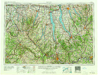
~ Elmira NY topo map, 1:250000 scale, 1 X 2 Degree, Historical, 1965
Elmira, New York, USGS topographic map dated 1965.
Includes geographic coordinates (latitude and longitude). This topographic map is suitable for hiking, camping, and exploring, or framing it as a wall map.
Printed on-demand using high resolution imagery, on heavy weight and acid free paper, or alternatively on a variety of synthetic materials.
Topos available on paper, Waterproof, Poly, or Tyvek. Usually shipping rolled, unless combined with other folded maps in one order.
- Product Number: USGS-5454843
- Free digital map download (high-resolution, GeoPDF): Elmira, New York (file size: 17 MB)
- Map Size: please refer to the dimensions of the GeoPDF map above
- Weight (paper map): ca. 55 grams
- Map Type: POD USGS Topographic Map
- Map Series: HTMC
- Map Verison: Historical
- Cell ID: 68766
- Scan ID: 138223
- Woodland Tint: Yes
- Visual Version Number: 1
- Field Check Year: 1962
- Datum: Unstated
- Map Projection: Transverse Mercator
- Map published by United States Geological Survey
- Map Language: English
- Scanner Resolution: 600 dpi
- Map Cell Name: Elmira
- Grid size: 1 X 2 Degree
- Date on map: 1965
- Map Scale: 1:250000
- Geographical region: New York, United States
Neighboring Maps:
All neighboring USGS topo maps are available for sale online at a variety of scales.
Spatial coverage:
Topo map Elmira, New York, covers the geographical area associated the following places:
- Vesper - Throop - Ritz Mobile Home Park - Golden Glow Heights - Nichols Corners - The Homes Of Wildflower Hills - Avoca - Jacksonville (historical) - Cumminsville - Holton Beach - Hammondsport - Locke - North Bloomfield - Ashantee - Southeast Owasco - Hornell - Perry City - Cedarcrest - Rolling Acres Mobile Home Park - Canandaigua Country Estate Mobile Home Park - Beachville - Gibson - Conesus - Pleasant Valley Mobile Home Park - Gibson Landing - Mapes - Riverside - Hemlock - Country Manor Estates - Rush - Elmira Heights - Ennerdale - Shepard Settlement - Phillips Creek - Guyanoga - Berkshire - Price Home - Burdett - Logan - East Lansing - Scottsburg - Tioga Terrace - Willow Beach - Cedar Park Terrace - Elm Valley - Rogersville - Allens Hill - South Canisteo - Head Corners - Farmington Manufactured Home Community - Airways Mobile Home Park - New Hope - Little York - Aldrich Trailer Park - Pine Hill Mobile Home Park - Geneva - Livingston Mobile Home Park - Moreland - Otisco - Savona Estates Mobile Home Park - Cloverland Park - Cameron - Pebble Beach - North Avon - Towlesville - Kenka Mills - Bosley Corner - Hesseney Mobile Home Park - Woodville - Baileys Settlement - Waterburg - Bradford - Centerfield - West Canadice Corners - Pioneer Village - Tuxedo Park - Loring Crossing - Heath Grove - Pleasant Valley - Birchland Park - Marathon - Van Vleet - Bennetts - Nanticoke - Canoga - Wileyville - Young Hickory - Brooks Grove - Cameron Mills - Tomlinson Corners - Bath - Greenville - Seeley Creek - East Avon - Jones Beach - Owego - Ensenore - Barton - Ellistown - Northrup's of West Bloomfield Mobile Home Park
- Map Area ID: AREA4342-78-76
- Northwest corner Lat/Long code: USGSNW43-78
- Northeast corner Lat/Long code: USGSNE43-76
- Southwest corner Lat/Long code: USGSSW42-78
- Southeast corner Lat/Long code: USGSSE42-76
- Northern map edge Latitude: 43
- Southern map edge Latitude: 42
- Western map edge Longitude: -78
- Eastern map edge Longitude: -76


