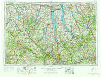
~ Elmira NY topo map, 1:250000 scale, 1 X 2 Degree, Historical, 1962, updated 1973
Elmira, New York, USGS topographic map dated 1962.
Includes geographic coordinates (latitude and longitude). This topographic map is suitable for hiking, camping, and exploring, or framing it as a wall map.
Printed on-demand using high resolution imagery, on heavy weight and acid free paper, or alternatively on a variety of synthetic materials.
Topos available on paper, Waterproof, Poly, or Tyvek. Usually shipping rolled, unless combined with other folded maps in one order.
- Product Number: USGS-5454841
- Free digital map download (high-resolution, GeoPDF): Elmira, New York (file size: 18 MB)
- Map Size: please refer to the dimensions of the GeoPDF map above
- Weight (paper map): ca. 55 grams
- Map Type: POD USGS Topographic Map
- Map Series: HTMC
- Map Verison: Historical
- Cell ID: 68766
- Scan ID: 138222
- Imprint Year: 1973
- Woodland Tint: Yes
- Visual Version Number: 1
- Edit Year: 1968
- Field Check Year: 1962
- Datum: Unstated
- Map Projection: Transverse Mercator
- Map published by United States Geological Survey
- Map Language: English
- Scanner Resolution: 600 dpi
- Map Cell Name: Elmira
- Grid size: 1 X 2 Degree
- Date on map: 1962
- Map Scale: 1:250000
- Geographical region: New York, United States
Neighboring Maps:
All neighboring USGS topo maps are available for sale online at a variety of scales.
Spatial coverage:
Topo map Elmira, New York, covers the geographical area associated the following places:
- Wallace - Grotto - Ironsides - Fisher Mobile Home Park - Ingleside - Ross Corners - Ferenbaugh - East Nichols - Old Orchard Point - Kennedy Corner - McDuffie Town - Whipple Corner - Stannards - Butcher Corner - South Livonia - Pleasant View Mobile Home Park - Thomas Estates Mobile Home Park - Boughton Hill - Moravia - Wagon Wheel Mobile Home Park - McGraws - Lewis (historical) - Glen Grove - Trumbull Corners - Kenka Mills - Farleys - Union Corners - West Newark - Osgood Landing - Amber - Semans Corner - Conklin Cove - Watkins Glen - Kelloggsville - Spring Mills - Sunflower Acres Mobile Home Park - Avon - Mapes - Skaneateles Falls - Sagetown - East Groveland - Ennerdale - Alpine Junction - Townsendville - Lake Country Estates - Fowlerville - Kanona - Whitesville - Swift Corner - Endwell - Fort Hill - Poplar Ridge - Mead Corner - Beachville - Cascade - Canandaigua Country Estate Mobile Home Park - East Scott - Golah - Navarino - Bishopville - Shamrock - Bristol - East Homer - Willow Beach - Caywood - Havana Glen Mobile Home Park - Phelps - West Corners - Hunt Hollow - Hornby - Victor - Jasper - Hubbardtown - Sacketts Harbor - West Cameron - Lacy Corners - Green Valley Mobile Manor - North Star Manufactured Home Community - Bergen Beach - Killawog - Garlinghouse - Gilbert - Mottville - Fairfield - Rathbone - North Spencer - West Elmira - Chipman Corners - Van Dorn Corner - Owego - Peoria - East Union - Harper Park Mobile Home Park Lima - Borden - Billsboro - West Canadice Corners - J and M Green Acres Mobile Home Park - Karrdale - Caton - Hartsville
- Map Area ID: AREA4342-78-76
- Northwest corner Lat/Long code: USGSNW43-78
- Northeast corner Lat/Long code: USGSNE43-76
- Southwest corner Lat/Long code: USGSSW42-78
- Southeast corner Lat/Long code: USGSSE42-76
- Northern map edge Latitude: 43
- Southern map edge Latitude: 42
- Western map edge Longitude: -78
- Eastern map edge Longitude: -76

