
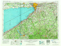
~ Buffalo NY topo map, 1:250000 scale, 1 X 2 Degree, Historical, 1967
Buffalo, New York, USGS topographic map dated 1967.
Includes geographic coordinates (latitude and longitude). This topographic map is suitable for hiking, camping, and exploring, or framing it as a wall map.
Printed on-demand using high resolution imagery, on heavy weight and acid free paper, or alternatively on a variety of synthetic materials.
Topos available on paper, Waterproof, Poly, or Tyvek. Usually shipping rolled, unless combined with other folded maps in one order.
- Product Number: USGS-5454829
- Free digital map download (high-resolution, GeoPDF): Buffalo, New York (file size: 15 MB)
- Map Size: please refer to the dimensions of the GeoPDF map above
- Weight (paper map): ca. 55 grams
- Map Type: POD USGS Topographic Map
- Map Series: HTMC
- Map Verison: Historical
- Cell ID: 68695
- Scan ID: 123052
- Woodland Tint: Yes
- Visual Version Number: 1
- Field Check Year: 1962
- Datum: Unstated
- Map Projection: Transverse Mercator
- Map published by United States Geological Survey
- Map Language: English
- Scanner Resolution: 600 dpi
- Map Cell Name: Buffalo
- Grid size: 1 X 2 Degree
- Date on map: 1967
- Map Scale: 1:250000
- Geographical region: New York, United States
Neighboring Maps:
All neighboring USGS topo maps are available for sale online at a variety of scales.
Spatial coverage:
Topo map Buffalo, New York, covers the geographical area associated the following places:
- Grover Cleveland Terrace - Hermitage - Attica Center - Chace - Long View - Beehive Crossing - Arkwright - Hillview Village Mobile Home Park - Rock City - McKinstry Hollow - Folsomdale - Pikeville - Connelly Park - Woodlawn - Bowmansville - Van Buren Point - Webster Corners - Persia - Bird - Brant - Ischua - Elton - Highland-on-the-Lake - Bowen - Colts Station - East Otto - Plants Corner - State Line - South Bolivar - East Leon - Weyer - Colburns - Orangeville Center - Marilla - Westons Mills - Chipmunk - Sprague Mobile Home Park - Keaches Corners - Maple Grove Mobile Home Estates - Dutchtown - Markhams - Maples - Parkside Village Mobile Home Park - Walden Cliffs - North Clymer - Morton Corners - Brocton - Greenhurst - Saint Vencent de Paul Camp - North Olean - Dewittville - Limestone - Brick House Corners - Fairview - Midway Park - Lamberton - New Albion - Glen of Saint Clare - Hermitage Meadow Mobile Home Park - Athol Springs - Snyder - Amherst - South Wales - Moons - Belfast - Hillcrest - Volusia - Java Village - Brook Gardens Mobile Home Park - Spragues Corner - Prendergast Point - Harborcreek - Farnham - Centerville - Black Corners - Jolee Mobile Home Community - Sucker Brook - Pleasantville - Niobe - Cottage - Franklinville - Ellington - Little Canada - Houghton - Transit Mobile Home Park - Arcade Valley Estates Mobile Home Park - Red House - Elkdale - Spring Brook Station - Cold Spring - Waterboro - Marshfield - Phillips Mills - Griswold - Ross Mills - Darien - West Clarksville - Lehigh - Porterville - Little Genesee
- Map Area ID: AREA4342-80-78
- Northwest corner Lat/Long code: USGSNW43-80
- Northeast corner Lat/Long code: USGSNE43-78
- Southwest corner Lat/Long code: USGSSW42-80
- Southeast corner Lat/Long code: USGSSE42-78
- Northern map edge Latitude: 43
- Southern map edge Latitude: 42
- Western map edge Longitude: -80
- Eastern map edge Longitude: -78


