
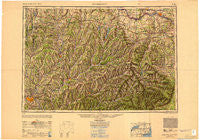
~ Binghamton NY topo map, 1:250000 scale, 1 X 2 Degree, Historical, 1950, updated 1950
Binghamton, New York, USGS topographic map dated 1950.
Includes geographic coordinates (latitude and longitude). This topographic map is suitable for hiking, camping, and exploring, or framing it as a wall map.
Printed on-demand using high resolution imagery, on heavy weight and acid free paper, or alternatively on a variety of synthetic materials.
Topos available on paper, Waterproof, Poly, or Tyvek. Usually shipping rolled, unless combined with other folded maps in one order.
- Product Number: USGS-5454821
- Free digital map download (high-resolution, GeoPDF): Binghamton, New York (file size: 15 MB)
- Map Size: please refer to the dimensions of the GeoPDF map above
- Weight (paper map): ca. 55 grams
- Map Type: POD USGS Topographic Map
- Map Series: HTMC
- Map Verison: Historical
- Cell ID: 68676
- Scan ID: 707229
- Imprint Year: 1950
- Woodland Tint: Yes
- Aerial Photo Year: 1944
- Datum: NAD27
- Map Projection: Transverse Mercator
- Shaded Relief map: Yes
- Map published by United States Army Corps of Engineers
- Map published by United States Army
- Map Language: English
- Scanner Resolution: 508 dpi
- Map Cell Name: Binghamton
- Grid size: 1 X 2 Degree
- Date on map: 1950
- Map Scale: 1:250000
- Geographical region: New York, United States
Neighboring Maps:
All neighboring USGS topo maps are available for sale online at a variety of scales.
Spatial coverage:
Topo map Binghamton, New York, covers the geographical area associated the following places:
- Fultonville Mobile Home Park - Pine Manor - Frone Corner - Occanum - Roseboom - West Oneonta - Smith Corner - Worcester - Peterboro - Beaver Springs Mobile Home Park - Castle Creek - Hessville - Barbourville - Flowers - Taylor Valley - Jewett Center - Burtonsville - Oriskany Falls - Oran - Owlsville - Stella (historical) - Hambletville - Gregorytown - Springfield - Solsville - Sweets - Edicks - Otego - Currytown - Seward - Greene - Hyndsville - Hawversville - Fultonville - Princetown - Westford - Barnerville - Ames - Pinewoods Mobile Home Park - West Settlement - North Bridgewater - Franklin Depot - Manny Corners - Scotch Bush - Hanley Corner - Margaretville - Gardnersville - Hagaman - Cobleskill - Gulf Summit - Helderberg - Arabia - Grand Gorge - Fraser - Fenton Mobile Home Park - Hartwick Heights Mobile Home Park - South Unadilla - Springfield Center - West Settlement - Sloansville - Richfield - New Ohio - Binghamton - Andes - Lathams Corners - Lincklaen Center - Westerlo - North Pharsalia - Wallins Corners - Engleville - Clintonville - Fabius - Freehold - Denver - South Brookfield - Tuscan - Mapledale - North Franklin - Portlandville - Fultonham - Georgetown - Otsdawa - Bonney - Roxbury - Pine Grove - Munnsville - Hartwick - Forest Manor - Winchell Manufactured Community - Van Hornesville - Clove - Clayville - Haines Falls - Purling - Pleasant Hill - Cascade Valley - Creekside Village - West Hill - West Middleburgh - West Winfield
- Map Area ID: AREA4342-76-74
- Northwest corner Lat/Long code: USGSNW43-76
- Northeast corner Lat/Long code: USGSNE43-74
- Southwest corner Lat/Long code: USGSSW42-76
- Southeast corner Lat/Long code: USGSSE42-74
- Northern map edge Latitude: 43
- Southern map edge Latitude: 42
- Western map edge Longitude: -76
- Eastern map edge Longitude: -74


