
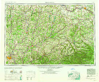
~ Binghamton NY topo map, 1:250000 scale, 1 X 2 Degree, Historical, 1963
Binghamton, New York, USGS topographic map dated 1963.
Includes geographic coordinates (latitude and longitude). This topographic map is suitable for hiking, camping, and exploring, or framing it as a wall map.
Printed on-demand using high resolution imagery, on heavy weight and acid free paper, or alternatively on a variety of synthetic materials.
Topos available on paper, Waterproof, Poly, or Tyvek. Usually shipping rolled, unless combined with other folded maps in one order.
- Product Number: USGS-5454819
- Free digital map download (high-resolution, GeoPDF): Binghamton, New York (file size: 18 MB)
- Map Size: please refer to the dimensions of the GeoPDF map above
- Weight (paper map): ca. 55 grams
- Map Type: POD USGS Topographic Map
- Map Series: HTMC
- Map Verison: Historical
- Cell ID: 68676
- Scan ID: 123307
- Woodland Tint: Yes
- Aerial Photo Year: 1944
- Datum: NAD27
- Map Projection: Transverse Mercator
- Map published by United States Geological Survey
- Map Language: English
- Scanner Resolution: 600 dpi
- Map Cell Name: Binghamton
- Grid size: 1 X 2 Degree
- Date on map: 1963
- Map Scale: 1:250000
- Geographical region: New York, United States
Neighboring Maps:
All neighboring USGS topo maps are available for sale online at a variety of scales.
Spatial coverage:
Topo map Binghamton, New York, covers the geographical area associated the following places:
- Coventry - Hartwick Heights Mobile Home Park - East Maine - Willow Point - Colliersville - Mallory Corner - Texas Valley - Richfield Springs - Sharon Center - Kirk - Tuscan - South Durham - Lower Cincinnatus - Bovina Center - Gregorytown - Itaska - Westford - West Meredith - West Jewett - Rotterdam Junction - Zena - South Amsterdam - Chapinville - Amblers Crossing - Vallonia Springs - East Guilford - Peck Hill - Rhode Island - Wolf Hill - Downsville - Shandaken - Port Crane - Tacoma - Sherburne Four Corners - Fountain Blue Mobile Home Park - Millers Mills Crossing - Pleasant Hill - Gulf Summit - Deck - North Fenton - Deansboro - Spinnerville - Van Hornesville - Wellsville - Fenner - Flat Creek - Five Corners - Cascade Valley - West Chenango - South Columbia - Chenango Lake - Gallupville - Guideboard - Small Corners - North Brookfield - Lloydsville - East Freetown - Howes Cave - South Westerlo - Nineveh Junction - Taylor - Glen Castle - Preston - South Plymouth - Flannerys Mobile Home Park - Hydeville - Hawleys - West Hill - Huntersland - Mapledale - Simpsonville - Hanover - Virginia City Mobile Home Court - Otselic - Beaver Springs Mobile Home Park - Buckley Hollow - Bridgewater - North Norwich - Knox - Waterville - Buel - Dorchester Estates - Snowdon - Nelson - Bearsville - Beyers Corners - Cuyler - South Gilboa Station - Cooperstown - Creekside Village - Church Corners - Canajoharie - Hagaman - Charlotteville - Pierceville - Cooperstown Junction - Wileytown - Wells Bridge - Springfield Center - Hawleyton
- Map Area ID: AREA4342-76-74
- Northwest corner Lat/Long code: USGSNW43-76
- Northeast corner Lat/Long code: USGSNE43-74
- Southwest corner Lat/Long code: USGSSW42-76
- Southeast corner Lat/Long code: USGSSE42-74
- Northern map edge Latitude: 43
- Southern map edge Latitude: 42
- Western map edge Longitude: -76
- Eastern map edge Longitude: -74


