
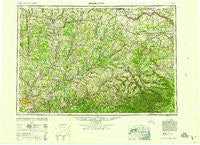
~ Binghamton NY topo map, 1:250000 scale, 1 X 2 Degree, Historical, 1958
Binghamton, New York, USGS topographic map dated 1958.
Includes geographic coordinates (latitude and longitude). This topographic map is suitable for hiking, camping, and exploring, or framing it as a wall map.
Printed on-demand using high resolution imagery, on heavy weight and acid free paper, or alternatively on a variety of synthetic materials.
Topos available on paper, Waterproof, Poly, or Tyvek. Usually shipping rolled, unless combined with other folded maps in one order.
- Product Number: USGS-5454817
- Free digital map download (high-resolution, GeoPDF): Binghamton, New York (file size: 20 MB)
- Map Size: please refer to the dimensions of the GeoPDF map above
- Weight (paper map): ca. 55 grams
- Map Type: POD USGS Topographic Map
- Map Series: HTMC
- Map Verison: Historical
- Cell ID: 68676
- Scan ID: 123306
- Woodland Tint: Yes
- Aerial Photo Year: 1944
- Datum: NAD27
- Map Projection: Transverse Mercator
- Map published by United States Geological Survey
- Map Language: English
- Scanner Resolution: 600 dpi
- Map Cell Name: Binghamton
- Grid size: 1 X 2 Degree
- Date on map: 1958
- Map Scale: 1:250000
- Geographical region: New York, United States
Neighboring Maps:
All neighboring USGS topo maps are available for sale online at a variety of scales.
Spatial coverage:
Topo map Binghamton, New York, covers the geographical area associated the following places:
- Riverside Mobile Home Park - Grand Gorge - Shackport - Saint Johnsville - Northwest Corners - Keesler Corners - Smith Corner - Lawyersville - Blatchley - Popes Ravine - Meadowbrooke Estates - Grovenor Corners - Purling - Fonda - North Settlement - South Worcester - Oaksville - Adams Corner - Otsdawa - Union Valley - Randallsville - Pattersonville - New Lisbon - Miller Corners - Platte Clove - West Exeter - Signal Mobile Home Park - Rockwells Mills - Westville - Stanbro - Oliverea - Clovesville - Wyman Corner - Jewett Center - Barbourville - Elliot Mobile Home Park - Sammonsville - West Jefferson - Shady - North Edmeston - Toddsville - Salem Corner - Harrisville - Beyers Corners - New Kingston - Braman Corners - Gothicville - Cullen - Conklin Forks - Amblers Crossing - Wyatts - Buckley Hollow - West Harpersfield - Readburn - Upper Barbourville - East Windsor - Lake Hill - West Charlton - Lakeville - Fultonham - Seager - Lower Genegantslet Corner - Westover - Breakabeen - Wellsville - Hinmans Corners - Ballards Mobile Home Park - Days Corners - Page Brook - Greene - Nineveh - Conklin - Willow - Durham - Hawversville - Ritchfield Junction - Index - Howes - Preston Center - Mount Carmel - East Windham - Andes - East Winfield - Peck Hill - East Cobleskill - High Woods - Leonta - Woodland - Duanesburg - South Berne - Stilesville - Harvard - Sages Crossing - Cleaver - Gilboa - Dogtown - Minaville - Riverside - Phoenix Mills - Franklin Depot
- Map Area ID: AREA4342-76-74
- Northwest corner Lat/Long code: USGSNW43-76
- Northeast corner Lat/Long code: USGSNE43-74
- Southwest corner Lat/Long code: USGSSW42-76
- Southeast corner Lat/Long code: USGSSE42-74
- Northern map edge Latitude: 43
- Southern map edge Latitude: 42
- Western map edge Longitude: -76
- Eastern map edge Longitude: -74


