
~ Albany NY topo map, 1:250000 scale, 1 X 2 Degree, Historical, 1956, updated 1976
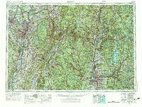
Albany, New York, USGS topographic map dated 1956.
Includes geographic coordinates (latitude and longitude). This topographic map is suitable for hiking, camping, and exploring, or framing it as a wall map.
Printed on-demand using high resolution imagery, on heavy weight and acid free paper, or alternatively on a variety of synthetic materials.
Topos available on paper, Waterproof, Poly, or Tyvek. Usually shipping rolled, unless combined with other folded maps in one order.
- Product Number: USGS-5454811
- Free digital map download (high-resolution, GeoPDF): Albany, New York (file size: 22 MB)
- Map Size: please refer to the dimensions of the GeoPDF map above
- Weight (paper map): ca. 55 grams
- Map Type: POD USGS Topographic Map
- Map Series: HTMC
- Map Verison: Historical
- Cell ID: 68639
- Scan ID: 136556
- Imprint Year: 1976
- Woodland Tint: Yes
- Photo Revision Year: 1974
- Aerial Photo Year: 1973
- Field Check Year: 1956
- Datum: Unstated
- Map Projection: Transverse Mercator
- Map published by United States Army
- Map Language: English
- Scanner Resolution: 600 dpi
- Map Cell Name: Albany
- Grid size: 1 X 2 Degree
- Date on map: 1956
- Map Scale: 1:250000
- Geographical region: New York, United States
Neighboring Maps:
All neighboring USGS topo maps are available for sale online at a variety of scales.
Spatial coverage:
Topo map Albany, New York, covers the geographical area associated the following places:
- North Nassau - Great Swamp - Cold Spring - Fryeville - Sand Lake - Scotia - Pine View Estates - Greylock - Pontoosuc - Waterville - South Egremont - East Springfield - Ballston Center - Stearnsville - Omi - Jonesville - Williamstown - East Hadley - Haydenville - Mundale - North Stephentown - Leverett - Oakdale - Merrick - Groom Corners - Lakewood - Smith Landing - Rosemont Park - Larrywaug - West Sand Lake - Greendale - Albrights - Barre Falls - Hinsdale - Norwich - Woodford - Becket Center - Sandisfield - Bemis Heights - Blush Hollow - Alsen - Hadley - Harper Acres - West Royalston - Albia - Ludlow - Camp Marion White - Dalton - Stillwater Center - Highlands - Otter River - Southwick - Greenfield - Baconville - Searsville - Queechy - Schonowe - Malta Gardens - Claverack - Country Knolls - Malta Gardens Trailer Park - Dwight - Guilford Center - Gill - Brightside - Erving - Moody Corner - Berkshire Heights - Stones Mobile Manor - North Otis - Houghtonville - Buckleyville - Burton Meadows - Hansons Mobile Home Park - Halifax - East Sheffield - Huntington - Swanzey Station - Indian Fields (historical) - Moores Corner - Manorton - Cummington - Fort Lucas - Coons - Tivoli - Weatogue - Fullers - Northfield Farms - Leisure Lee - Schodack Landing - Rindge - Cushman - Glasco - Rockdale Mills - Camp Howe - Wangum Village - East Nassau - Fort Hunter - Gayhead - Stamford
- Map Area ID: AREA4342-74-72
- Northwest corner Lat/Long code: USGSNW43-74
- Northeast corner Lat/Long code: USGSNE43-72
- Southwest corner Lat/Long code: USGSSW42-74
- Southeast corner Lat/Long code: USGSSE42-72
- Northern map edge Latitude: 43
- Southern map edge Latitude: 42
- Western map edge Longitude: -74
- Eastern map edge Longitude: -72


