
~ Albany NY topo map, 1:250000 scale, 1 X 2 Degree, Historical, 1948, updated 1951
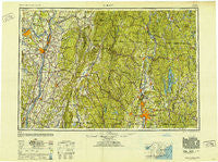
Albany, New York, USGS topographic map dated 1948.
Includes geographic coordinates (latitude and longitude). This topographic map is suitable for hiking, camping, and exploring, or framing it as a wall map.
Printed on-demand using high resolution imagery, on heavy weight and acid free paper, or alternatively on a variety of synthetic materials.
Topos available on paper, Waterproof, Poly, or Tyvek. Usually shipping rolled, unless combined with other folded maps in one order.
- Product Number: USGS-5454803
- Free digital map download (high-resolution, GeoPDF): Albany, New York (file size: 18 MB)
- Map Size: please refer to the dimensions of the GeoPDF map above
- Weight (paper map): ca. 55 grams
- Map Type: POD USGS Topographic Map
- Map Series: HTMC
- Map Verison: Historical
- Cell ID: 68639
- Scan ID: 136545
- Imprint Year: 1951
- Woodland Tint: Yes
- Aerial Photo Year: 1945
- Datum: NAD27
- Map Projection: Transverse Mercator
- Map published by United States Army Corps of Engineers
- Map published by United States Army
- Map Language: English
- Scanner Resolution: 600 dpi
- Map Cell Name: Albany
- Grid size: 1 X 2 Degree
- Date on map: 1948
- Map Scale: 1:250000
- Geographical region: New York, United States
Neighboring Maps:
All neighboring USGS topo maps are available for sale online at a variety of scales.
Spatial coverage:
Topo map Albany, New York, covers the geographical area associated the following places:
- Bronck House - Ashley Falls - The Street - West Warren - South Ashfield - Northwood Estates - Mystic Grove - Tarrytown - Camp Russell - Snellville (historical) - Garfield - Groom Corners - New Scotland - East Greenville - Southwest Hoosick - East Poestenkill - Hubbardston - Rockdale Mills - West Northfield - Pine Haven Motor Home Park - Annandale-on-Hudson - Taconic Shores - South Albany - Hansons Mobile Home Park - Hoosick - West Otis - Old Hill - South Wendell - Greenwich Village (historical) - Packard Heights - Stony Hill - Cedar Hill - Newton Hook - Cramer Woods - Washington - Braeside - Montague Station - Colemans Trailer Park - Eagle Bridge - Copake Lake - Little River - Ashuelot - Hubbard Corner - East Otis - Humphreysville - Center Cambridge - Hillsdale - Brooks Village - O'Briens Corner - East Wilbraham - Savoy - Lone Pine Community Mobile Home Park - Whitingham - Jo-nel Mobile Home Park - Lakewood - Berlin - Dublin - Alcove - Whitneyville - Morey Park - Lakeview Terrace - East Westmoreland - Oakdale - Lee - Vining Hill - Pitcherville - East Hoosick - Swift River - Deans Mill - Burton Meadows - Thompson Trailer Park - Camp Rowe - North Farms - Nonatomqua Mobile Home Park - North New Salem - Twin Lakes - Golden Acres - Blush Hollow - Leeds - West Chesterfield - Riviera Estates - Roxbury Center - Poolsburg - Hoosac Tunnel Station - East Brimfield - Chesterfield - East Hillsdale - Rising Corner - Wheatleigh - Bon Acre - Burrage Corner - North Hollow - Lanesborough - Carmen Courts - East Glenville - Ware Center - Chatham Center - Earlton - West Rindge - Hallum Trailer Park
- Map Area ID: AREA4342-74-72
- Northwest corner Lat/Long code: USGSNW43-74
- Northeast corner Lat/Long code: USGSNE43-72
- Southwest corner Lat/Long code: USGSSW42-74
- Southeast corner Lat/Long code: USGSSE42-72
- Northern map edge Latitude: 43
- Southern map edge Latitude: 42
- Western map edge Longitude: -74
- Eastern map edge Longitude: -72


