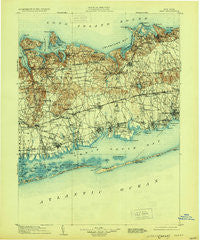
~ Islip NY topo map, 1:125000 scale, 30 X 30 Minute, Historical, 1904, updated 1930
Islip, New York, USGS topographic map dated 1904.
Includes geographic coordinates (latitude and longitude). This topographic map is suitable for hiking, camping, and exploring, or framing it as a wall map.
Printed on-demand using high resolution imagery, on heavy weight and acid free paper, or alternatively on a variety of synthetic materials.
Topos available on paper, Waterproof, Poly, or Tyvek. Usually shipping rolled, unless combined with other folded maps in one order.
- Product Number: USGS-5454777
- Free digital map download (high-resolution, GeoPDF): Islip, New York (file size: 7 MB)
- Map Size: please refer to the dimensions of the GeoPDF map above
- Weight (paper map): ca. 55 grams
- Map Type: POD USGS Topographic Map
- Map Series: HTMC
- Map Verison: Historical
- Cell ID: 65743
- Scan ID: 130069
- Imprint Year: 1930
- Survey Year: 1902
- Datum: NAD
- Map Projection: Polyconic
- Map published by United States Geological Survey
- Map Language: English
- Scanner Resolution: 600 dpi
- Map Cell Name: Islip
- Grid size: 30 X 30 Minute
- Date on map: 1904
- Map Scale: 1:125000
- Geographical region: New York, United States
Neighboring Maps:
All neighboring USGS topo maps are available for sale online at a variety of scales.
Spatial coverage:
Topo map Islip, New York, covers the geographical area associated the following places:
- Eatons Neck - Crystal Brook - Medford - Commack - Woodbury - Port Jefferson - Plainview - Sayville Heights - North Amityville - Ocean Bay Park - Gildersleeve Park For Mobile Homes - Elwood - South Huntington - North Lindenhurst - Islip Terrace - Vernon Valley - Copiague Harbor - Amityville - Head of the Harbor - Babylon - Belle Terre - Fire Island Pines - Central Islip - Bay Shore - Holbrook - Terryville - East Brentwood - Swedetown Village - Huntington Station - Saltaire - Halesite - Centereach - Lindenhurst - Village of the Branch - Lakeland - Wincoma - Lonelyville - West Amityville - Farmingville - West Bay Shore - Huntington - Robbins Rest - Port Jefferson Station - Point o'Woods - East Setauket - Lower Melville - Bayport - The Landing - Harbor Green - Islip - Lake Grove - Northport - Huntington Bay - Gilgo Beach - Holtsville - West Sayville - Brentwood - Lefferts Mill - Bay Wood - Seaview - Melville - Farmingdale - Islandia - Old Bethpage - Kismet - Seaford - Maywood - Nassau Shores - Lake Ronkonkoma - Bunker Hill Mobile Home Court - Greenlawn - West Gilgo Beach - Cold Spring Harbor - Atlantique - Wyandanch - Ronkonkoma - Massapequa - Mount Sinai - Fair Harbor - West Islip - Kings Park - Selden - Plainedge - East Islip - North Bay Shore - Half Hollow - North Massapequa - Water Island - Coram - West Babylon - South Farmingdale - North Patchogue - South Setauket - Nesconset - Poquott - Frontier Park - Smithtown - Patchogue - Wheatley Heights - East Farmingdale
- Map Area ID: AREA4140.5-73.5-73
- Northwest corner Lat/Long code: USGSNW41-73.5
- Northeast corner Lat/Long code: USGSNE41-73
- Southwest corner Lat/Long code: USGSSW40.5-73.5
- Southeast corner Lat/Long code: USGSSE40.5-73
- Northern map edge Latitude: 41
- Southern map edge Latitude: 40.5
- Western map edge Longitude: -73.5
- Eastern map edge Longitude: -73

