
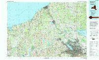
~ Syracuse NY topo map, 1:100000 scale, 30 X 60 Minute, Historical, 1985, updated 1994
Syracuse, New York, USGS topographic map dated 1985.
Includes geographic coordinates (latitude and longitude). This topographic map is suitable for hiking, camping, and exploring, or framing it as a wall map.
Printed on-demand using high resolution imagery, on heavy weight and acid free paper, or alternatively on a variety of synthetic materials.
Topos available on paper, Waterproof, Poly, or Tyvek. Usually shipping rolled, unless combined with other folded maps in one order.
- Product Number: USGS-5454755
- Free digital map download (high-resolution, GeoPDF): Syracuse, New York (file size: 24 MB)
- Map Size: please refer to the dimensions of the GeoPDF map above
- Weight (paper map): ca. 55 grams
- Map Type: POD USGS Topographic Map
- Map Series: HTMC
- Map Verison: Historical
- Cell ID: 68433
- Scan ID: 136946
- Imprint Year: 1994
- Woodland Tint: Yes
- Visual Version Number: 2
- Aerial Photo Year: 1980
- Edit Year: 1985
- Datum: NAD27
- Map Projection: Universal Transverse Mercator
- Map published by United States Geological Survey
- Map Language: English
- Scanner Resolution: 600 dpi
- Map Cell Name: Syracuse
- Grid size: 30 X 60 Minute
- Date on map: 1985
- Map Scale: 1:100000
- Geographical region: New York, United States
Neighboring Maps:
All neighboring USGS topo maps are available for sale online at a variety of scales.
Spatial coverage:
Topo map Syracuse, New York, covers the geographical area associated the following places:
- Liberty Park Mobile Home Park - Little France - Lake Bluff - Hinsdale - Lyons - Hidden Acres Mobile Home Park - Maiden Lane Mobile Home Park - Phoenix - Constantia - Pitcher Hill - Elmcrest - Conquest - Pember Corners - Angells Corner - Martisco - Crocketts - Oswego Center - Mosquito Point - Union Settlement - Ira - East Syracuse - West Shore Mobile Home Park - Toad Harbor - Conifer Mobile Home Park - Martville - Long Branch - Howland - Upson Corners - South Granby - Hastings - Clark Lane Mobile Home Park - South Hannibal - Three Rivers - Van Buren - Forest Beach - Red Rock - Bonni Castle - Volney - Gayville - Gilbert Mills - Peru - Hortontown - Dutch Settlement - Lewis Corners - The Patch (historical) - Brown Center - Country Haven Mobile Home Park - Stiles - Powell Mobile Home Park - Memphis - Albion Center - Hillcrest East Mobile Home Park - Willow Grove - Elbridge - Taunton - Loomis Hill - Savannah - Lycoming - Hannibal Hills Mobile Home Park - North Volney - Belgium - Baird Corners - Quiet Acres Mobile Home Park - DeWitt - West Genesee Terrace - Oswego Bitter - North Victory - Southwest Oswego - Michael O'Brian's Mobile Home Park - Amboy - Foland Trailer Park - North Hannibal - Red Mill - Jones Point - Mallory - Ingalls Crossing - Shady Brook Mobile Home Park - North Huron - Hilltop Trailer Park - Oot Park - South Scriba - Bayberry - Bowens Corners - Glenmark - Minetto - Green Acres Mobile Court - Loomis Corner - Graftons Square - Wayne Center - Roosevelt Corners - Ionia - Winter Mobile Home Park - Fairmount - Whig Hill - Cicero - Hammonds Corner - North Belle Isle - Baldwinsville - Hickory Square - Moon Beach
- Map Area ID: AREA43.543-77-76
- Northwest corner Lat/Long code: USGSNW43.5-77
- Northeast corner Lat/Long code: USGSNE43.5-76
- Southwest corner Lat/Long code: USGSSW43-77
- Southeast corner Lat/Long code: USGSSE43-76
- Northern map edge Latitude: 43.5
- Southern map edge Latitude: 43
- Western map edge Longitude: -77
- Eastern map edge Longitude: -76


