
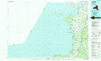
~ Pulaski NY topo map, 1:100000 scale, 30 X 60 Minute, Historical, 1985
Pulaski, New York, USGS topographic map dated 1985.
Includes geographic coordinates (latitude and longitude). This topographic map is suitable for hiking, camping, and exploring, or framing it as a wall map.
Printed on-demand using high resolution imagery, on heavy weight and acid free paper, or alternatively on a variety of synthetic materials.
Topos available on paper, Waterproof, Poly, or Tyvek. Usually shipping rolled, unless combined with other folded maps in one order.
- Product Number: USGS-5454735
- Free digital map download (high-resolution, GeoPDF): Pulaski, New York (file size: 17 MB)
- Map Size: please refer to the dimensions of the GeoPDF map above
- Weight (paper map): ca. 55 grams
- Map Type: POD USGS Topographic Map
- Map Series: HTMC
- Map Verison: Historical
- Cell ID: 68200
- Scan ID: 136837
- Woodland Tint: Yes
- Visual Version Number: 1
- Aerial Photo Year: 1980
- Edit Year: 1985
- Datum: NAD27
- Map Projection: Universal Transverse Mercator
- Planimetric: Yes
- Map published by United States Geological Survey
- Map Language: English
- Scanner Resolution: 600 dpi
- Map Cell Name: Pulaski
- Grid size: 30 X 60 Minute
- Date on map: 1985
- Map Scale: 1:100000
- Geographical region: New York, United States
Neighboring Maps:
All neighboring USGS topo maps are available for sale online at a variety of scales.
Spatial coverage:
Topo map Pulaski, New York, covers the geographical area associated the following places:
- Giddingsville - Lyon Corner - Clark Point - Henderson Harbor - Babbitt Corner - Montario Point - Thomas Settlement - Pine Ridge Mobile Home Park - Sandy Pond - Henderson - Sackets Harbor - Jefferson Park - Lakeview - Adams - Jefferson Courts Mobile Home Park - Pineville - Demster Beach - Farmers Corner - Woodville - Altmar - Bethel Corners - Lacona - Rural Hill - North Adams - Hungerford Corners - Wardwell - Lapointe Manor Mobile Home Park - Saxe Corner - Texas - North Landing - Jewettville - Richland - Shore Oaks - Green Settlement - The Elms - Alverson - Tylers Corner - Brennan Beach Mobile Home Park - Smithville - Selkirk - Taylor Settlement - Butterville - Pierrepont Manor - Belleville - Ellisburg - North Church Corner - Community Park - Roberts Corner - Camps Mills - Sandy Creek - Daysville Corner - Baggs Corner - Tinker Tavern Corner - Boultons Beach - Cobbtown - Rainbow Shores - Green Haven Mobile Home Community - Daysville - Ramona Beach - Allendale - Hickory Grove - Centerville - Mannsville - Pulaski - Sulphur Springs - North Boylston - Port Ontario - Pillar Point - Sandy Acres Mobile Home Park - Adams Center
- Map Area ID: AREA4443.5-77-76
- Northwest corner Lat/Long code: USGSNW44-77
- Northeast corner Lat/Long code: USGSNE44-76
- Southwest corner Lat/Long code: USGSSW43.5-77
- Southeast corner Lat/Long code: USGSSE43.5-76
- Northern map edge Latitude: 44
- Southern map edge Latitude: 43.5
- Western map edge Longitude: -77
- Eastern map edge Longitude: -76


